Pumping week of surf ahead

Victorian Surf Forecast by Craig Brokensha (issued Friday 19th May)
Best Days: Saturday, Monday, Tuesday, Wednesday, Thursday morning, Friday, next Saturday/Sunday
Features of the Forecast (tl;dr)
- Building mid-period SW swells Fri PM with mod-fresh W/NW tending variable into the PM
- Moderate sized mix of SW swells Sat with fresh W/NW winds
- Building moderate sized swell later Sat, peaking Sun with strong W/SW-SW winds, possibly W/NW for a short period early on the Surf Coast
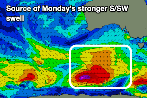
- Mod-large SW swell building Sun, peaking out of the S/SW Mon with W/NW-NW tending W/NW winds
- Smaller Tue, with a reinforcing pulse of S/SW swell for the PM, easing slowly Wed
- Gusty N/NW-NW winds Tue, NW Wed
- New mid-period S/SW swell Thu AM with gusty W/NW winds ahead of a W/SW change
- Large SW swell building later Thu, peaking Fri with gusty NW winds
Recap
Super fun waves on the Surf Coast yesterday with easing 3-4ft sets, clean also to the east but a little chunky for some exposed beaches, still 4-6ft.
Today we've got a temporary low point in swell back to 2ft to occasionally 3ft on the Surf Coast and 4ft to the east, and morning W/NW winds should hold until at least early afternoon, if not going variable for the rest of the afternoon.
A new mix of S/SW and SW swells are due to pulse to 3ft and 4-5ft respectively offering fun waves for the afternoon knock off.
This weekend and next week (May 20 - 26)
Tomorrow will be a fun day for the Surf Coast as this afternoon's mix of new mid-period swells holds through the morning with surf to 3ft west of Melbourne and 4-5ft to the east under gusty W/NW winds.

A new pulse of moderate sized SW swell is due to arrive into the afternoon, generated by a good fetch of pre/post frontal W/NW and W/SW winds moving in along the polar shelf yesterday, with it currently south-west of Tasmania today.
4ft sets are due to develop on the Surf Coast magnets mid-late afternoon, with the swell holding into Sunday morning.
Unfortunately a strengthening cold front pushing up and into us during Sunday will bring strong W/SW-SW winds from dawn on Sunday, with only a slight chance of early W/NW winds on the Surf Coast. These won't last long, but the front will also bring with it a moderate to large pulse of building mid-period SW swell that is expected to reach 6ft and 8ft respectively to the west and east of Melbourne through the afternoon.
Monday looks the pick of this frontal progression, with a stronger pulse of S/SW groundswell due to arrive, generated by gale-force winds at the base of the front pushing through Sunday.
Winds will swing back offshore from the W/NW-NW, holding out of the W/NW into the afternoon along with good, 6ft waves on the Surf Coast (possible rare bigger one magnets) with 8ft surf to the east.
More favourable and fresh N/NW-NW winds are due on Tuesday as the swell drops back to 4ft or so on the Surf Coast and 6ft+ to the east. A reinforcing pulse of mid-period S/SW swell should maintain this surf all day, generated by another healthy polar frontal system pushing in from the east under the country on Sunday.
Similar to Sunday's progression, slightly stronger, more polar W/SW winds will produce a reinforcing S/SW swell that will slow the easing tend into Wednesday with good 3-4ft sets due early, easing through the day on the Surf Coast along with 6ft sets to the east. Gusty NW winds will favour the Surf Coast all day, only swinging from W/NW to W/SW on Thursday as a cold front clips us.
Size wise, another pulse of mid-period S/SW swell should maintain 3-4ft waves on the Surf Coast through the morning Thursday, but into the afternoon and more so Friday we're looking at a large, extended SW swell event. This will be due to the frontal activity increasing through the end of the week, pushing up closer towards us while generating gale-force winds.
The models are still slightly divergent, but EC has been consistent with it's forecast, and this should result in building size through Thursday, peaking Friday to 6-8ft on the Surf Coast and 8-10ft to the east.
This looks to be with favourable winds from the north-western quadrant, with reinforcing large pulses likely into next weekend. We'll have a closer look at this on Monday but in short, next week will pump. Have a great weekend!
Comments
Excellent!
I think I love you Craig
Love it Craigos !
Craig returns from holidays and brings punctual AND pumping foreys! Imagine having to wait until 5pm for this report..!
Craigpots producing the goods as usual!
Torquay cam offline again??
We have an NBN issue in TQ this morning, trying to fix.
ah crap i'm on my way to QLD and forecast there is for 1-2ft all week
typical
Sounds like you have the same luck i have any time i venture up the east coast of Aus, goes flat and vic pumps......
North NSW looks good, maybe venture south It was pumping there all week
Craigos you mongrel dog you!
A forey to behold!
exciting times ahead limp biscuit!
Haha, no worries crew.
bravo
Nice forecast Craig, going to have to pace myself. Wishing I'd shaped that bigger board over summer... In fact wish I'd updated the lot of winter boards as still rocking the 2015 ones for the most
Wow that's some longevity!
Borrow a board anytime VJ, too many to mention but have a few very well suited to cold water overhead walls from 6’8 to 7’10. Not getting as much use with a 9 month old. Although I’m sure I’ll be finding some ocean time over the week ahead ;) Hmmmmmm might even book a house
Love you Craig
It’s been a while
74 knot / 137kmh gust at Wilsons Prom early this morning. Pretty wild out in Bass Strait today.