Varying swell pulses building from Friday afternoon

Victorian Surf Forecast by Craig Brokensha (issued Wednesday 17th May)
Best Days: Later morning to mid-afternoon today, tomorrow morning Surf Coast, Friday morning Surf Coast, early Saturday and Sunday on the Surf Coast, Monday, Tuesday and Wednesday Surf Coast
Features of the Forecast (tl;dr)
- Moderate sized mid-period SW swell easing through tomorrow with W/NW tending SW winds mid-late AM
- Building mid-period SW swells Fri PM with mod-fresh W/NW tending W/SW winds
- Moderate sized mix of SW swells Sat with early N/NW tending strong SW winds
- Building moderate sized swells Sun with strong W/SW-SW winds, early W/NW on the Surf Coast
- Mod-large S/SW groundswell Mon with mod-fresh W/NW winds
- Easing surf Tue with fresh NW winds, stronger N/NW Wed
Recap
A large SW groundswell filled in yesterday but a cold front brought a strong SW change just before first light, creating poor conditions across most locations. Protected spots offered quality waves, while this morning we've got an easing swell with average conditions continuing thanks to a moderate to fresh S/SE breeze.
Winds are easing and improving to the east this morning and we should see them tend NE, more variable to the west ahead of S'ly sea breezes.
This week and weekend (May 18 - 21)
The end of the week will favour the Surf Coast as we see winds tend W/NW tomorrow morning as the swell continues to ease in size, dropping back from the 3-4ft range on the Surf Coast and 5-6ft to the east.
The slow easing tend will be thanks to a moderate sized, reinforcing mid-period S/SW swell filling in this morning.
Winds will shift SW mid-late morning so try and surf before then.
A temporary low point in swell is due Friday morning though still coming in at 2-3ft on the Surf Coast magnets and 4ft+ to the east under a moderate to fresh W/NW breeze. We should see some new, moderate sized mid-period SW swell energy building through the afternoon as winds shift W/SW-SW and freshen, generated by a mix of unconsolidated polar and closer-range frontal activity.
At this stage the Surf Coast looks to build back to 3ft, with 4-5ft sets to the east though with those onshore winds.
Moving into the weekend we'll see the size ease back slowly on Saturday morning and you'll have to surf early as a N/NW offshore will give into a strong SW change mid-morning.
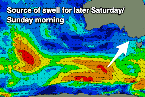
This front will be attached to a stronger, polar frontal progression, bringing with it a moderate sized increase in mid-period SW swell for later in the day, peaking Sunday, while a secondary front pushing into us on Sunday will build wave heights further into the afternoon, followed by a S/SW groundswell on Monday, peaking into the afternoon.
All this activity will build on the fetches before it, with strong to gale-force reaching maximum strength in our southern swell window on Saturday, and this will produce building size that looks to come in at 4ft Sunday morning on the Surf Coast, 6ft to the east, with building surf to 5ft and 6-8ft respectively through the afternoon, peaking Monday to 6ft and 8ft west and east of Melbourne.

Local winds on Sunday will be dicey and strong from the W/SW-SW, with a short window of early W/NW winds on the Surf Coast, much better Monday and out of the W/NW all day.
A slow drop in size is expected through Tuesday and Wednesday along with NW winds on Tuesday that will strengthen from the N/NW on Wednesday.
Longer term there's plenty more potential for later in the week and next weekend but we'll have a closer look at this on Friday.
Comments
Defo noticing more swells outta the S/SW which was pretty prominent through La Niña. What’s the general reasoning for this? Possibly a gradual transition back to more W/SW typical of El Niño? Or the happy medium of a neutral stage?
How big will it be saturday?
half a "garry"
Too big for any tubbabird that's for sure. Craigos will be on his 6'4 Knifing it out at the corner. And Shetrickedme will be deep behind the curtain late on Saturday night!
TubbaB - as a fellow disciple of Lord Craigos you must read his scripture with keen and discerning eyes.
Easing back slowly from 3ft before going onny and gettin' bigger.
Will she or won’t she go onshore dilemma, WillyWeather, local off shores always make me think , hopefully arvo sesh too.
Someone on my account stitched me up Seabiscuit! A snake in the grass!
Open your ear holes Tubbabird
How's that (possible) deep low/big swell inbound for the following weekend. Sheesh!
It's interesting, BOM central forecasts a SSW <10kts and every model on windy looks that way for 8am Thursday - but I just know it'll be that W/NW that you say, and a quick trip outside feels like the lightest of S up here at this late time. Hmmm....
It's crisp and offshore :)
Surf conditions yesterday at the North side of The Island were good but the crowds ( A week day FFS!) were too much for this Kook for life. I think next week I 'll need to find somewhere in W.P. that is not too busy .