Good run for exposed coasts

Victorian Surf Forecast by Craig Brokensha (issued Wednesday 12th April)
Best Days: Tomorrow morning exposed beaches, Friday to the east, Saturday to the east, Sunday morning for the keen Surf Coast, Monday, Tuesday
Features of the Forecast (tl;dr)
- Inconsistent SW groundswell tomorrow with light E/SE-SE winds, freshening into the PM (E/NE in the AM to the east)
- Inconsistent, moderate sized W/SW groundswell building later tomorrow, peaking Fri AM, with a slightly smaller reinforcing pulse for late Fri, easing slowly Sat
- Fresh but easing E/NE tending NE winds Fri
- Strong N/NE tending N winds Sat
- Small start to Sun, with a new SW swell arriving into the PM with W/NW-NW tending stronger W/SW-SW winds
- ** Small sized mid-period SW swell Mon AM, easing steadily with N/NW tending N/NE winds (check comment below) **
- Easing surf Tue with local offshore tending variable winds
- Moderate sized + W/SW groundswell for next Thu with S winds
Recap
A mix of easing S/SW swell and new, inconsistent SW groundswell coming in around 3ft on the Surf Coast magnets and 4ft to the east with improving conditions under variable winds. The exposed beaches to the east were great into the afternoon, with the Surf Coast beaches also performing best.
This morning the swell is slower and smaller with heavy rain pushing through ahead of a mid-latitude low. The Surf Coast is best on the beaches and to 2ft, with clean, inconsistent 3ft waves to the east.
This week and weekend (Apr 13 - 16)
Tomorrow will remain on the small, slow side as background levels of inconsistent groundswell to mostly 2ft on the Surf Coast and 3ft to the east, with the odd bigger set across both coasts for the patient.
Winds look only light in the morning but E/SE-SE on the Surf Coast, and E/NE across the exposed beaches to the east, freshening from the SE into the afternoon.
Friday will see fresher E/NE winds early, easing and tending NE through the morning and becoming light into the afternoon with a mix of new, inconsistent W/SW groundswells.
The first swell which is due to arrive later tomorrow, peaking Friday morning was generated by a strong low pushing up from the Heard Island region, south-west of Western Australia, with a secondary similar system moving in quickly behind it, producing a slightly smaller, reinforcing pulse for the late afternoon that will ease slowly Saturday.
Expect inconsistent 3ft to occasionally 4ft sets on the Surf Coast magnets, (2-3ft elsewhere) and 5-6ft sets to the east most of Friday, easing back from 3ft+ and 5ft+ on Saturday morning.
With those winds the beaches to the east look best but a little tricky size wise, stronger Saturday and out of the N/NE, shifting N'ly through the day.
This will be ahead of a new mid-latitude low, resulting in weaker W/NW-NW winds on Sunday morning that will then strengthen and tend W/SW-SW through the afternoon.
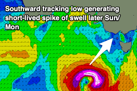
Now, as discussed on Monday, a strong mid-latitude low is due to form in the Bight on the weekend, with it actually 'bombing'. This doesn't mean it'll be good for swell production though, with it due to bomb while quickly dropping south through our swell window on Saturday.
A tight fetch of gale to severe-gale winds should produce a small-moderate sized mid-period SW swell that should build Sunday afternoon, peaking Monday morning.
We're looking at 2ft+ waves on the Surf Coast in the morning Sunday, 4ft to the east, with the new swell building to 3ft and 5ft respectively later in the day but with the SW winds.

Monday should see steadily easing surf from 3ft to possibly 4ft on the Surf Coast magnets, 5ft+ to the east along with N/NW tending N/NE winds. With the swell easing through the afternoon, locations to the east should be fun and manageable.
Tuesday looks smaller and with local offshore winds and variable afternoon breezes.
Following the funky mid-latitude activity we've got some better swell producers lining up in the way of proper cold fronts pushing in through the Bight from next week (left). This should generate some decent W/SW groundswell with possibly S'ly winds at this early stage. More on this Friday.
Comments
Just an update regarding the low generating Monday's swell, latest updates have downgraded it quite a bit (was a flukey system anyway), though both GFS and EC were strong this morning.
So don't expect much in the way of size for Monday, maybe 2ft Surf Coast and 3ft to the east. There might be some slightly better mid-period W/SW swell in the mix but I'll update Friday.
Winds have likely switched to cyclonic SE also just for a little extra kick in the nuts
I’m still seeing nw though dx. What wind forey you using?
I'm using the 'give it time and it'll turn to absolute shit on the surf coast' model. Find it very consistent in terms of accuracy and reliability.
Downgrade. Of course it has..
Ha, was never gonna be a great swell from that low Grey.
That 16 dayer must be one of the best you've published for several years Craig nice job. Pipe opener?