Stormy weekend, tricky winds next week with varying pulses of swell

Victorian Surf Forecast by Craig Brokensha (issued Friday 7th April)
Best Days: Beaches today, stormy options Sunday, Tuesday morning to the east, Wednesday ahead of the change, Friday
Features of the Forecast (tl;dr)
- Low point in swell tomorrow AM with early W/NW tending strong SW winds
- Building SW windswell tomorrow PM
- Large, stormy mid-period S/SW swell filling in Sun with strong SW tending S/SW winds
- Easing swell Mon with gusty S/SW winds
- Easing S/SW swell Tue, with an inconsistent SW groundswell in the mix
- Early S winds Tue, tending variable to the east ahead of sea breezes
- Small-mod Inconsistent backgroundswells for Wed/Thu with local offshore N winds, shifting W/NW into the PM ahead of a late SW change Wed
- W/NW tending E/SE winds Thu
- Inconsistent W/SW groundswell building later Thu, peaking Fri AM, with a better pulse of W'ly swell for Fri PM
- Gusty N/NE winds Fri
Recap
The new mid-period S/SW swell filled in on cue yesterday with building sets quickly to 3ft across the Surf Coast and 4ft to the east and we saw the odd bigger one to 4ft on the Surf Coast as the swell peaked into the afternoon/evening. There were even some 5ft sets at Bells/Winki which was a bit above expectations from a fairly mediocre swell source.
This morning the swell is on the ease with north-east winds favouring the beaches again, coming in at 3ft to the east and 2-3ft on the Surf Coast. A trough is stalling to our west and this will result in N/NE winds holding most of the day now ahead of a late change so hit the beaches.


Swell on the pump yesterday PM
This weekend and next week (Apr 8 - 14)
The weekend will be wild and wooly with an early offshore wind due across the Surf Coast tomorrow but with a low point in swell, swinging SW through the day and strengthening as a polar front pushes up behind a weak, mid-latitude low pushing east across us this evening.
A drawn out fetch of strong S/SW winds will be projected up and into us through tomorrow and Sunday, lingering Monday as a broad, powerful low forms in the Tasman Sea.
A building windswell should be seen tomorrow afternoon, with a peak in mid-period energy due through Sunday, building to a stormy 6ft on the Surf Coast and 6-8ft to the east but with strong SW tending S/SW winds.
Winds will ease a touch on Monday but remain gusty from the S/SW creating poor conditions with slowly easing levels of mid-period swell from 4-5ft or so on the Surf Coast and 6ft to the east.
Tuesday is a tricky one as the low in the Tasman Sea is expected to weaken and push east resulting in a rapid easing of winds and pressure gradients over the state.
A dawn S'ly wind may tend variable through the morning to the east, while likely just tending SE on the Surf Coast with a mix of easing S'ly windswell and inconsistent SW groundswell.
The groundswell has been generated by the initial stages of the front pushing into us this weekend. It'll be inconsistent but to 3ft on the Surf Coast magnets, 3-5ft to the east, easing Wednesday from 2-3ft and 4ft respectively as winds shift to the N'th and locally offshore.
An approaching cold front is likely to shift winds to the W/NW into the afternoon ahead of a late SW change so surf before then.
Thursday looks to remain slow with background levels of groundswell in the inconsistent 2ft+ range on the Surf Coast (rare 3ft one magnets) and 3-4ft to the east with a morning W/NW breeze ahead of E/SE sea breezes.
Later in the day a small pulse of inconsistent W/SW groundswell is due, peaking Friday morning ahead of a secondary pulse of W/SW groundswell into the afternoon.
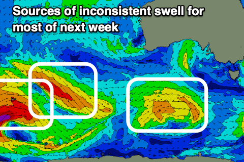
The source of these swells is a strong but patchy progression of frontal systems projecting up towards and under Western Australia from this weekend through next week.

A small, initial low only looks to generate inconsistent 2-3ft sets on the Surf Coast Friday morning, with 4-5ft sets to the east, while a stronger but more northerly located front will generate W'ly gales in our western swell window on Tuesday.
A further pulse to an inconsistent 3-4ft is likely on the Surf Coast magnets Friday afternoon with 6ft sets to the east along with strengthening N/NE winds ahead of the frontal progression moving in from the west.
NW to SW winds are likely Saturday morning as the swell starts to ease, ahead of some better W/SW groundswell later Sunday/Monday but we'll have a closer look at this on Monday. Have a great weekend and rug up!