Fun end to the week on the beaches, poor weekend, improving next week

Victorian Surf Forecast by Craig Brokensha (issued Wednesday 5th April)
Best Days: Thursday, Friday morning, Tuesday morning, Wednesday morning exposed beaches, Friday and Saturday next week
Features of the Forecast (tl;dr)
- Small-mod sized S/SW swell filling in tomorrow with moderate N/NE-NE winds
- Small, easing S/SW swell Fri with early N/NE winds to the east, shifting N/NW to the west through the AM, with a shallow SW change into the PM
- Strong SW winds Sat with a building SW windswell
- Moderate sized + mid-period S/SW Sun (peaking PM) with strong SW tending S/SW winds
- Easing swell Mon strong S/SW winds, slowly easing
- Inconsistent SW groundswell for Tue along with easing S/SW swell
- Variable winds Tue AM ahead of S/SE sea breezes
- Fading surf Wed with fresh N/NE winds
- Inconsistent W/SW groundswell building later Thu, peaking Fri with NW winds
- Stronger W/SW groundswell for later Fri, peaking Sat
Recap
Good waves across the exposed beaches yesterday morning, easing from 3-4ft to the east and 2ft to occasionally 3ft on the Surf Coast with light morning winds, bumpy into the afternoon.
This morning the swell is reaching a low point with workable waves for the desperate on the exposed beaches.
This week and next (Apr 6 - 14)

The coming days are looking fun for a surf, especially on the exposed beaches with a new pulse of mid-period S/SW swell due to fill in tomorrow, peaking through the afternoon before easing Friday.
A relatively weak but persistent and favourably positioned polar front pushed through our southern swell window yesterday, with the Surf Coast due to come in at 3ft through the day (possible rare bigger set magnets at the peak) with 4ft+ surf to the east.
Winds will favour the beaches with a morning N/NE-NE breeze due to hold most of if not all of the day.
Friday will offer a window early to the east with dawn N/NE winds, shifting N'ly mid-late morning and then NW ahead of a shallow SW change.
The swell will ease quickly though with sets dropping from 2ft+ on the Surf Coast and 3ft to the east.
Saturday will still be a lay day as a strong SW change moves in just before dawn, kicking up a localised SW windswell through the day ahead of some larger, stronger mid-period energy on Sunday.
The source of this swell will be a polar front pushing up from the south-west, with it merging with the backside of the weak mid-latitude low currently in the Bight.
This will see a fetch of strong S/SW winds projected up through our southern swell window and Bass Strait through Saturday and Sunday, kicking up a building swell from 3-4ft to 4-5ft through the afternoon on the Surf Coast and kicking to 6ft+ to the east.
Conditions will be poor though with strong SW tending S/SW winds that will remain gusty into Monday morning as the swell starts easing.

So all in all the Long Weekend looks poor for a surf before an early on Friday before the tide gets to the easing swell.
On Tuesday, lighter and more variable winds should develop across both regions along with some inconsistent, long-range groundswell from the earlier stages of the polar front pushing up and into us on the weekend.
That being a tight fetch of gale to severe-gale W/NW winds around the Heard Island region today. Inconsistent sets to 3ft are due on the Surf Coast magnets most of the day (generally 2-3ft) with 3-5ft sets to the east. Conditions are likely to be lumpy following onshore winds Monday evening before afternoon S/SE sea breezes kick in.
Wednesday will become smaller as Tuesday's swell eases and conditions look much cleaner and lined up with a fresh N/NE breeze.
Now as touched on in Monday's notes, we're looking at increasing Southern Ocean storm activity developing in the Heard Island region this weekend, with it forecast to project east-northeast up towards Western Australia through the early to middle stages of next week.
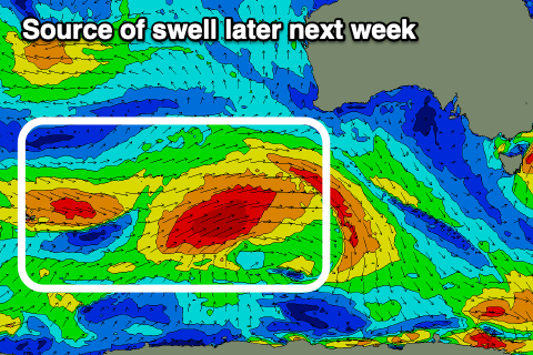
It looks like an initial strong frontal system will generate a moderate sized W/SW groundswell for later Thursday and Friday morning, ahead of a secondary stronger but more northerly positioned low, generating more size into later Friday and Saturday morning.
There's plenty more activity to follow it as well but it all looks to be a little too late for the Rip Curl Pro waiting period. This will come as welcome news to most surfers though.
At this stage the sizes are still up in the air but the first swell looks to be a slow 3-4ft Friday morning on the Surf Coast and 6ft to the east, with the secondary low generating surf more towards 4-5ft+ and 8ft respectively. Winds look to be favourable and out of the western quadrant, but check back Friday for a clearer idea in the timings and sizes.
Comments
Are the waiting periods set in stone? Just push it back a day!
Yes I believe they are thankfully
Horrendous for the pro. Run heats/finals at bells and winki at same time on Friday the 14th. Split screen. Bang done , pack that shit up and go.
Think they will run Friday morning?
I seem to remember some small high tide Rincon heats in the past.
Kids are keen to see Kelly ...
They ran finals at small high tide Rincon last year so it’s certainly a possibility.
Ah yeah true.
Is this the worst forecast in the history of the comp?
girls are scoring glassy 3ft winki as we speak.
Last year's forecast was way worse by memory - SE winds and 1 foot slop. Last year hadn't even broken from the SE summer slop cycle by the time of the comp and then something materialised that was quite decent (then small on finals day) - it was very suprising that they got anything at all.
At least this year we have had a few swells already and the Sw swell pattern is established