Tricky week with fun options, especially on the beaches Thursday

Victoria Forecast by Craig Brokensha (issued Monday 3rd April)
Best Days: Today ahead of sea breezes, tomorrow morning, Thursday on the beaches, Friday morning
Features of the Forecast (tl;dr)
- Slow, easing mid-period swell tomorrow and Wed
- Light, local offshore winds tomorrow AM, becoming mod-fresh S into the PM
- Mod-fresh S/SE winds Wed
- Small-mod sized S/SW swell filling in Thu with mod-fresh NE tending E/NE winds (possible variable winds late Surf Coast and N/NE to the east)
- Easing S/SW swell Fri with fresh N/NW winds ahead of a shallow PM W/SW change
- Low point in swell Sat with fresh W/NW tending strong S/SW winds
- S/SW windswell Sun with fresh S/SW winds
- Easing swell Mon with W/NW tending S/SW winds
Recap
The building swell seen through Friday afternoon peaked on Saturday but conditions were average-poor thanks to a gusty onshore wind. Yesterday provided much better conditions with a light, local offshore wind across the Surf Coast and lumpy surf either side of 4ft, with lumpy 5-6ft waves to the east.
This morning winds are again favourable across both regions with easing 3ft sets on the Surf Coast and 3-5ft sets to the east. Winds will hold until around early afternoon when weak E/SE sea breezes are due to kick in, freshening through the rest of the afternoon. So get a surf in this morning.

Solid, clean waves this AM
This week and weekend (Apr 4 - 9)
Looking at the week ahead, and the Rip Curl Pro waiting period is due to kick off tomorrow, with a full forecast update provided tomorrow.
Surf wise, the current swell energy will continue to ease with a slow drop from 2ft+ across the Surf Coast magnets tomorrow, 3ft+ to the east along with variable, local offshore winds before a trough brings increasing S’ly winds through the afternoon though only moderate to fresh.
Wednesday looks a touch smaller and to a very inconsistent 2ft on the Surf Coast with 2-3ft sets to the east but with lingering, moderate to fresh S/SE winds in the wake of tomorrow’s trough.
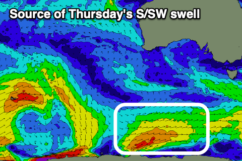
Into the end of the week we’ve got a fun pulse of mid-period S/SW swell due, generated by a relatively weak but favourably positioned polar front developing south of the country today. A fetch of strong SW tending W/SW winds will be projected through our southern swell window, with the mid-period energy expected to build through Thursday and peak into the afternoon.
The Surf Coast is expected to build to 3ft, with the Mornington Peninsula building to 4ft to occasionally 5ft but moderarte to fresh morning NE winds will favour the beaches, tending E/NE through the day. A little trough may create variable winds later in the day on the Surf Coast and swing winds N/NE to the east later.
Friday will see N/NW winds ahead of a mid-afternoon W/SW change as the S/SW swell eases back from 2ft+ on the Surf Coast and 3ft+ to the east.
Looking at the weekend and the surf will bottom out into Saturday with freshening W/NW winds ahead of a strong S/SW change as a weak mid-latitude low forming in the Bight pushes east, crossing us bringing the shift in winds.

A weak, localised S/SW swell will be generated by the trailing fetch with the Surf Coast jumping to 3ft or so Sunday but with fresh S/SW winds, 4-5ft to the east.
Winds are likely to tip back to the W/NW on Monday morning but with easing levels of swell from Sunday.
Longer term the Southern Ocean looks to become more active with a larger W/SW groundswell possible into the end of next week, but we’ll keep an eye on this and provide updates on Wednesday and Friday.
Comments
So in other words Bells will be very poor. And maybe not run thru Easter at all?
Last roll of the dice on GFS looking decent
WSL may luck out