Improving surf today on the beaches

Victorian Surf Forecast by Craig Brokensha (issued Wednesday 22nd February)
Best Days: Today exposed beaches, Saturday on the exposed beaches ahead of the change, Tuesday morning
Features of the Forecast (tl;dr)
- Fading mix of small SE windswell tomorrow and S/SW energy with strong N/NE winds, easing later
- Low point in swell Fri with strong N/NE winds
- Inconsistent, mid-period W/SW swell building Sat, peaking Sun AM
- Strong N/NE winds Sat, ahead of a S/SW-SW change late AM
- Strong SW winds Sun
- Moderate sized SW groundswell building Mon with strong but easing S/SW-S winds
- Easing groundswell Tue with variable winds ahead of sea breezes
Recap
The swell kicked slowly through Monday with sets to 4-5ft across the Surf Coast magnets into the afternoon ahead of a stronger pulse in size on dark, easing back yesterday from 3-5ft but with poor, strong S/SE winds. Locations to the east were also poor and wind affected with 6ft sets.
This morning we've got strong E'ly winds and a mix of SE windswell and easing mid-period S/SW swell from 3ft on the Surf Coast and 3-4ft to the east.
Winds will swing more E/NE during the day and likely ease a little as the mix of swells continue to east. Beaches to the east should be fun all day.

Windy peaks this AM
This week and weekend (Feb 23 - 26)
The end of the week isn't too crash hot, with clean conditions expected across the exposed beaches into tomorrow under a strong N/NE breeze but with no decent size.
Fading 1-2ft sets are due across both regions, with it being SE windswell on the Surf Coast and S/SW energy to the east.
Friday will see similar, strong N/NE winds that will persist all day but no surf.
Moving into the weekend we should see an inconsistent but fun sized mid-period W/SW swell starting to build Saturday afternoon, peaking Sunday.
This has been generated by a healthy but distant polar low that formed in the Heard Island region, with a fetch of sub-gale-force W/NW-W/SW winds projecting east-northeast. The system is weakening while to the south-west of Western Australia with the inconsistent swell due to come in at 2-3ft on the swell magnets across the Surf Coast and 4-5ft to the east on later Saturday and Sunday morning.
Winds on Saturday will be strong from the N/NE again, with a window for the exposed beaches as the swell starts building before giving into a strong S/SW-SW change into the late morning and afternoon as the swell gets stronger.
Strong SW winds will unfortunately spoil the swell into Sunday, possibly lighter and W/SW at dawn on the Surf Coast but we'll review this on Friday.
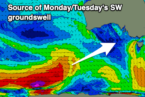
Following the low linked to Sunday's swell, a stronger polar front firing up along the shelf will generate a great fetch of severe-gale W'ly winds and a moderate sized SW groundswell for Monday, peaking into the afternoon.
Unfortunately winds will be strong out of the S/SW in the wake of the weekend's trough, easing into the afternoon with Tuesday possibly seeing more variable morning winds.
The swell should reach 4ft across the Surf Coast and 5-6ft to the east Monday afternoon, easing slowly from 3-4ft and 5-6ft on Tuesday.
The easing trend will be slowed thanks to the drawn our nature of the polar front, but the models diverge on the winds thanks to unstable weather in the region. Check back here on Friday for the latest.
Comments
Not very often that Lorne is bigger than Portsea.
Looks like that change might be coming through fairly early on Saturday morning? This weekend is my first chance to surf since 1 Jan. Desperate to get back into it.
Agh yes it's been brought forward, bummer. Dawn N winds, gusty, shifting N/NW by 8am and then onshore shortly after..
Looks like the incoming trough will stall a little. Keep an eye out for the update today.
Saw that, thanks.
Fun and peaky when the coast runs in reverse. Like being on east coast.
Indeed!