Improving weekend but with weak, small surf

Victorian Surf Forecast by Craig Brokensha (issued Wednesday 4th January)
Best Days: Keen surfers PI tomorrow morning, selected beaches Friday morning, Saturday morning exposed beaches for the keen
Features of the Forecast (tl;dr)
- Easing mid-period SW swell tomorrow with fresh S/SE-S winds, lighter E/SE across PI in the AM
- Small, reinforcing mid-period S/SW swell Fri with gusty E/SE tending strong SE winds
- Easing small mix of swells Sat with E/NE-NE tending SE winds
- Small, weak surf Sun with NE tending SE winds
- Small, inconsistent W/SW swell Mon with variable tending strong S/SW winds mid-morning
- Building W/SW swell Tue with strong S/SW winds, peaking Wed with fresh E/SE tending SE winds
- Easing surf Thu with fresh E/NE tending SE winds
Recap
Small, average surf yesterday though workable across the exposed beaches to the east with S'ly winds, poorer today with stronger S/SW winds but a bit more size. There's nowhere really offering a quality wave.
This week and next (Jan 5 - 13)
Today's increase in mid-period swell is due to start easing through tomorrow and conditions will remain average across most spots with a fresh S/SE-S'ly wind. Phillip Island should see lighter E/SE winds, offering lumpy options for the keen along with easing 3-4ft sets, while the Surf Coast should drop back from 2ft+.
`
Winds will shift more E/SE on Friday morning but be fresh in strength, opening up a few more options as a small, mid-period S/SW swell fills in. The swell was generated by a weak polar front that's currently south-west of Tasmania and should maintain small 2ft sets on the Surf Coast and 3-4ft sets to the east.
Strong SE winds are due into the afternoon, kicking up a localised windswell on the Surf Coast, with a small mix of SE windswell and S/SW swell due to ease on Saturday as winds improve and swing E/NE-NE through the morning.
Peaky, fading 1-2ft waves are expected on the Surf Coast, 2-3ft to the east, smaller Sunday under a morning NE breeze.
A low point in swell is expected on Monday and a surface trough is due to move through mid-morning bringing strengthening S/SW winds.
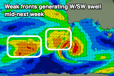
A decent pulse of W/SW groundswell that was forecast by both EC and GFS has been downgraded, with the frontal progression linked to this now due to be much weaker.
Winds weren't going to be ideal in any case with strong S'ly breezes due in the wake of Monday's change on Tuesday, while swinging gusty E/SE on Wednesday.
The mid-period W/SW swell energy should build Tuesday afternoon but peak Wednesday, generated by back to back mid-latitude fronts generating fetches of strong W'ly winds to the south-west of Western Australia. A peak to 3ft is due on the Surf Coast magnets Wednesday and 4-5ft to the east but with those E/SE winds.
Thursday looks better and cleaner on the beaches as the swell eases under an E/NE offshore, smaller and weaker Friday.