Window of funky waves tomorrow

Victorian Surf Forecast by Craig Brokensha (issued Monday 5th November)
Best Days: Tomorrow morning all locations, Saturday and Sunday mornings on the beaches
Features of the Forecast (tl;dr)
- Building S windswell today, easing tomorrow with variable SE winds on the Surf Coast, light E/NE to the east ahead of sea breezes
- Small to tiny Wed AM from the SE and S/SW
- Moderate sized + SW groundswell building into the PM, peaking overnight, easing Thu
- Strengthening SW winds Wed, strong SW tending S/SW Thu
- Easing surf Fri with moderate S/SE winds
- Inconsistent W/SW swell for Sat PM, Sun and Mon AM
- Light E/NE-NE tending SE winds Sat, fresh NE Sun tending strong W/SW
Recap
Saturday saw a drop in swell but improving conditions to the east of Melbourne with 3-4ft sets and favourable winds until mid-late afternoon. Yesterday remained around a fun though inconsistent 3ft range across the exposed beaches with great morning conditions, becoming wind affected into the afternoon as a NW'y developed.
This NW'ly was ahead of a trough and strong SW change, leaving no options for a quality wave.
This week and weekend (Dec 6 - 11)
The week ahead will unfortunately be spoilt by troughy/onshore weather and winds thanks to back to back mid-latitude lows pushing through the region, followed by high pressure into the weekend (which will see improving conditions).
Today's change is linked to a deepening inland low moving across us, and a fetch of strong S'ly winds produced just off Tasmania's West Coast will kick up a moderate sized, stormy swell this afternoon that will ease tomorrow.
Winds should relax as the low pushes east, tending E/NE across the beaches to the east with variable SE winds on the Surf Coast. This looks to be a window worth making the most of with lumpy, improving surf ahead of afternoon sea breezes and easing sets from 3ft on the Surf Coast and 4ft to the east.
Wednesday morning looks possibly clean early on the Surf Coast (but tiny), though winds will quickly strengthen from the SW as a cold front pushes up and into us. There might be a sneaky SE swell sneaking through Bass Strait and from the Tasman Sea on Wednesday, though the fetch sitting east of Tasmania isn't ideally aimed.
Wednesday's strengthening onshore winds will kick up some weak SW windswell into the afternoon, with winds persisting Thursday from the SW tending S/SW. These onshore winds will spoil our strong SW groundswell that's due into Wednesday afternoon and Thursday, arriving a little earlier than expected on Friday.
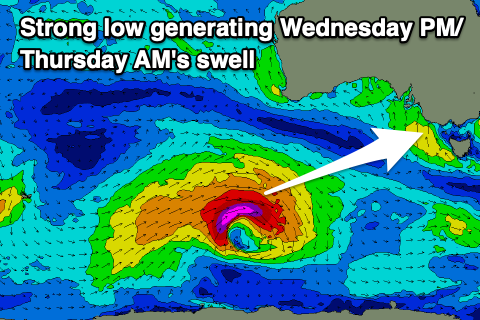
The strong polar low linked to this swell has formed to the south-southwest of Western Australia, with a fetch of severe-gale to, at times storm-force W/SW winds being projected through our south-western swell window. The low will weaken into this evening while being aimed more into the polar shelf, leaving the groundswell to spread out arrive through Wednesday.
Due to the slightly stronger core winds, we should see an earlier arrival, with it building into Wednesday afternoon and evening, likely reaching 3-4ft by dark on the Surf Coast and 6ft on the sets to the east, with a peak due into the evening, easing Thursday. The Surf Coast looks to ease from 4-5ft on the magnets, 6ft to possibly 8ft to the east but with those strong onshore winds.
The surf should continue to ease through Friday as winds start shifting S/SE thanks to a high moving in from the west, cleaner Saturday with a morning E/NE-NE breeze but smaller surf.
The Surf Coast looks to be easing from 2ft, better on the beaches but only to 3ft.
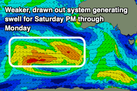
A small mid-period W/SW swell should steady wave heights into the afternoon and Sunday, generated by a weak low moving through our medium-range swell window, south-west of Western Australia over the coming days.
Inconsistent sets to 1-2ft are due on the Surf Coast and 3ft to the east along with favourable NE winds Sunday morning ahead of a strong afternoon W/SW change.
This change looks to be linked to another trough, come mid-latitude low but we'll have a closer look at this on Wednesday.
Comments
it makes me happy not hearing 'mid lattitude low' :)
I note the weather is broken again this week.
Glad we had such a good run in the last couple of weeks!