Hit the beaches tomorrow before action returns to the Surf Coast

Victorian Surf Forecast by Craig Brokensha (issued Friday 25th November)
Best Days: Tomorrow on the beaches, Monday Surf Coast, early Tuesday Surf Coast, Wednesday morning Surf Coast, Friday morning
Features of the Forecast (tl;dr)
- Small mid-period SW swells tomorrow, peaking in the PM with strengthening N/NE-NE winds, tending NW into the evening
- Small leftovers Sun with W/NW tending strong SW winds
- Moderate sized mix of SW swells Mon with moderate W/NW-W winds
- Moderate sized mid-period SW swell building Tue with early W/NW tending gusty SW-S/SW winds mid-late AM
- Moderate-large SW groundswell for later Tue, peaking Wed with NW tending S winds
- Easing surf Thu with S/SE winds
- Moderate sized reinforcing SW swell Thu PM, easing Fri with N/NE tending SE winds
Recap
Wednesday's large pulse of S/SW groundswell started to ease through yesterday but the Surf Coast magnets were still picking up 4-6ft sets with great conditions, one of the better mornings of the year.
To the east the swell was back t 4-5ft and cleaner with the lighter winds, while all locations were average into the afternoon with onshore breezes.
Today the swell is easing further in size and power with leftover 3ft sets on the Surf Coast magnets, 3-4ft to the east but with persistent onshore winds. A lighter onshore breeze is due to develop through the day to the east, creating improving conditions for the keen.
This weekend and next week (Nov 26 – Dec 2)
Looking at the weekend and tomorrow will be the pick with some fun new mid-period SW swells due to fill in as winds strengthen but remain offshore for the beaches until an evening NW change moves through.
Strengthening N/NE-NE winds are due through the morning and afternoon, with a small pulse of weak W/SW swell for the morning due to be followed by a better SW swell late morning and into the afternoon.
These swells were generated by a weak low moving in, south of the country the last couple of days. A weak pre-frontal W/NW fetch was followed by a smaller, slightly stronger SW fetch. Sets to 2ft are due on the Surf Coast in the morning, 3-4ft to the east, with the better 2ft+ and 4ft waves respectively due from later morning.
Come Sunday the swell will be smaller and on the way out and a morning W/NW breeze will strengthen from the SW late morning.
This change in wind and increase in strength will be associated with a strengthening polar frontal progression forming to our south-west with a ton of swell due to move in through next week.
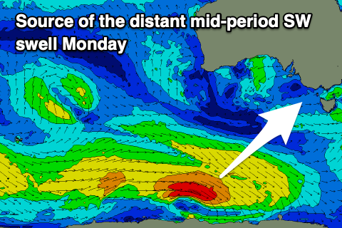 Firstly though, a polar front moving east along the shelf yesterday and today, south of Western Australia should generate a mid-period SW swell for Monday. A fetch of sub-gale-force W/NW winds will provide inconsistent 3ft sets on the Surf Coast with 4-5ft sets to the east.
There'll be a more consistent, localised mid-period SW swell present though, generated by Sunday's strengthening frontal system, with a burst of strong W/SW winds directly to our south-west due to produce a touch more size to 3ft+ on the Surf Coast and 4-6ft surf to the east.
Winds look favourable and W/NW for most of the day Monday as a secondary polar front starts pushing up towards us. We may see winds tend more W'ly at times but protected spots should be clean all day.
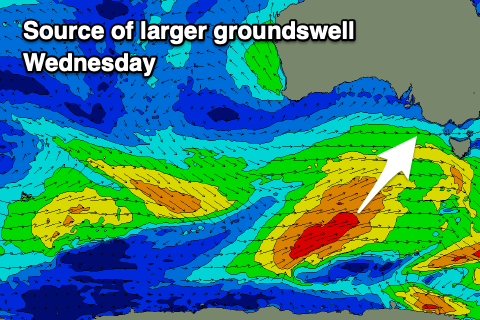
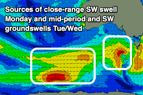 Now, looking at Tuesday/Wednesday, we've got building mid-period SW energy ahead of some less consistent groundswell thanks to a strong polar low pushing in from the Heard Island region. Initially and at distance to us, a fetch of strong to gale-force W/NW tending W winds will produce a SW groundswell for later Tuesday but more so Wednesday, while the remnants of the low are due to project up slowly towards us early next week, with some mid-period SW energy due to build on Tuesday.
Winds look dicey Tuesday and W/NW at dawn, gusty SW-S/SW from mid-late morning along with building surf to a consistent 4ft on the Surf Coast due through the day, 6ft to the east, with Wednesday coming in at 4-6ft and 6-8ft respectively.
 Conditions will improve Wednesday morning as winds shift back to the NW, light in nature ahead of S'ly sea breezes. A trough will move through during the afternoon, bringing that S breeze and a high following it looks to bring unfavourable S/SE winds through Thursday, better and offshore Friday morning with easing surf.
The swell looks to still be moderate in size Thursday and Friday thanks to a final low generating a reinforcing mid-period swell, but we'll have another look at this next week. Have a great weekend!
Comments
late spring is sure making up for a fairly crap winter
Thursday was an absolute cracker
It was very nice.
I love it when you start a sentence with "Now,....". It's always followed by good news. Thanks for another great forecast!
Ha, true. Thanks.
should i be concerned with MP water quality ?; just dont wanna get crook catching waves before I go to morocco to get crook catching waves.
Who would of thunk a titan would get sick from some water.
Gee we love to see things staying nice and polar in November. I’m hoping for a white Christmas if it means the waves will stay like this!
The Cold Coast.
People are saying there pumping water out at Gunna again but I can’t find anything on the net regarding it?
surely there's a duty of care arrangement involved - there should be signage and warnings if it's harmful.
Years ago it had a taste if your surfed up that the Rye end with a SE wind. Had a paddle down the other end and the water had that same taste.
There’s signs at the gunna lookout saying it’s happening
What is the company behind it?
South East water,
When it rains heavy extra water from the rain enters the sewer system through stormwater pipes being connected to sewer pipes and ground runoff enters the sewer system. Treatment plants can only treat a certain amount of water, when there is heavy rain they can't handle the extra water so they have to dump it somewhere. Carrum downs, Mt Matha, and Boneo all end up at Boags rocks St Andrews. Although Currum Downs also lets it go out at the Paterson River into the bay as the last resort.
The storm water is connected to the sewerage? I've never heard of this in a domestic or commercial situation.
Old joe blow decides to install his own downpipes and stormwater drain and accidentally connects to his sewer. Or a concrete path graded to drain into an overflow relief gully. There are lots of different ways stormwater can enter the sewer.
https://www.egwater.vic.gov.au/targeting-illegal-pipe-connections/
there is stok. epa is saying dont swim there.
sorry my bad 'melbourne water'
What’s the matter gunnamatta ?
I think these swells would be better served if they we're blessing the WA coast. Actually I am happy for you.
Some really fun waves this afternoon with the kick in swell. Looks tasty.
It was a good place to be around midday, little waves but clean, and 40m+ rides on the right equipment, the run continues...
Finally the surfcoast comes back
Only taken 2 years