Good swell spoilt by poor winds
Monday, 3 October 2022
Good swell spoilt by poor winds
Monday, 3 October 2022
We've got an upgrade in swell for the coming days but with generally poor conditions.
We've got an upgrade in swell for the coming days but with generally poor conditions.
Make the most of today across Margs before onshore winds kick in tomorrow afternoon and write-off the surf until later week.
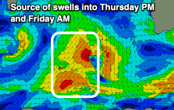
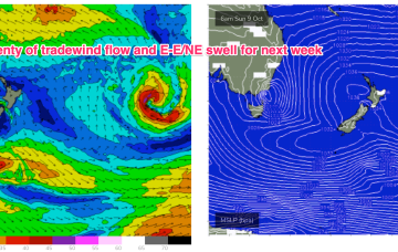
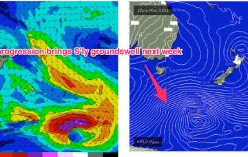
A much stronger high is moving into the classic La Niña slot- SE of Tasmania- where it will start to be squeezed by another approaching inland trough and complex low pressure system. That will see increasing E- NE winds come into play from mid-week with increasing levels of NE-E/NE windswell, especially on the Mid North Coast. Frontal progressions passing well to the south no longer have a strong surge into the Tasman but will send mid/long period pulses of S-SSE swell our way from mid week while a strong developing trade-wind flow will keep swell chugging away from the E into next week. A very active outlook for October.
A much stronger high is moving into the classic La Niña slot- SE of Tasmania- where it will start to be squeezed by another approaching inland trough and complex low pressure system. That will see increasing NE winds come into play from mid-week with increasing levels of NE-E/NE windswell.
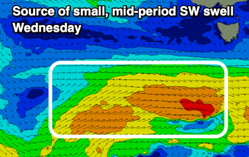
Besides tomorrow there'll be favourable winds and a fun swell from Wednesday, with a fun Mid Coast swell for the weekend, onshore down South.
Make the most of today as windows of clean conditions with any size will be limited over the coming period.
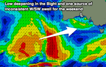
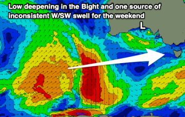
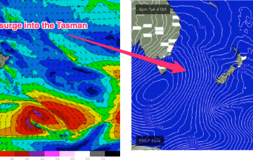
No great change to the weekend f/cast. Wind and swell regimens will be dominated by the low in the Tasman, which is now retreating towards the North Island with a large (1037hPa) high south of Tasmania. Pressure gradients do slowly ease over the weekend as the high relaxes over warm Tasman sea waters and the low sets up near the North Island.
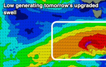
Decent surf on the weekend each morning, with options next week but not as big as it looks Wednesday.
No great change to the weekend f/cast. Wind and swell regimens will be dominated by the low in the Tasman, which is now retreating towards the North Island with a large (1037hPa) high south of Tasmania. Pressure gradients do slowly ease over the weekend as the high relaxes over warm Tasman sea waters and the low sets up near the North Island.
Windy and with a small swell for the weekend. Better early next week with a new westerly swell along with offshore winds.