Indonesia/Maldives forecast August 8th
Tuesday, 8 August 2023
Indonesia/Maldives forecast August 8th
Tuesday, 8 August 2023
A slower period of activity with swells mostly in the moderate sized + range.
A slower period of activity with swells mostly in the moderate sized + range.
A persistent tradewind fetch is in the process of resetting with a less favourable wind alignment and easing swells.
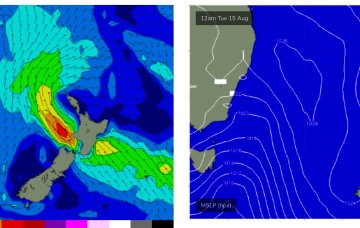
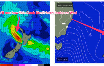
The remnants of a low/front near the South Island are lingering near the South Island through the short term with the next frontal system expected late this week. No major swell sources on the radar so lets look at a few bits and pieces on offer this week.
Get out this afternoon to make the most of the current swell. Some new energy is due on the weekend.
The surf will deteriorate tomorrow and then improve mid-late week across all locations.
A persistent tradewind fetch is in the process of resetting with a less favourable wind alignment and easing swells. No major swell sources on the radar so lets look at a few bits and pieces on offer this week.
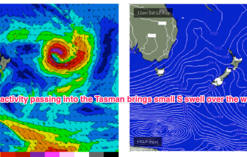
Another large high (1034hPa) is currently moving offshore from Southern NSW into the Tasman, with a long, NW-SE angled trough now moving offshore and towards the North Islands. The remnants of a low/front near the South Island are lingering near the South Island through the short term with the next frontal system expected late this week. No major swell sources on the radar so lets look at a few bits and pieces on offer this week.
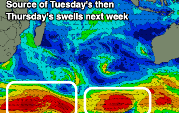
The coming period is more troughy and less frontal with fun swells and trickier winds.
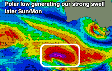
We've got light winds and easing size over the coming days ahead of a moderate sized mid-period swell event from Sunday with varying winds.
Today and tomorrow will offer windy surf, better into Sunday/Monday.