Indonesia/Maldives forecast August 8th

Indian Ocean Basin analysis by Craig Brokensha (issued Tuesday 8th August)
This week through next week (Aug 9 - 18)
Friday afternoon's large pulse of new long-period S/SW groundswell played out to plan, with large sets pusling strongly later in the day, peaking overnight and then easing slowly through Saturday while tending more S'th in direction.
The size eased through Sunday and further into Monday ahead of a new, building S/SW groundswell today.
This swell has boosted wave heights across most regions and should be followed by a reinforcing pulse of slightly bigger, more consistent mid-period SW swell tomorrow. The source of today's swell was a strong but late forming polar low to the south-west of Western Australia, with the reinforcing swell generated by a weaker but more northerly located low, closer towards Indonesia.
The easing trend looks to be slow through Thursday, Friday and the weekend thanks to weak, trailing frontal activity through the southern Indian Ocean. It looks like we'll be back to moderate sized surf come Friday/Saturday and smaller Sunday/Monday with fleeting pulses of background S/SW energy.
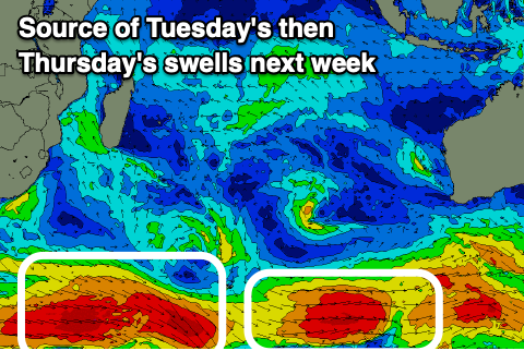
The next noticeable increase in energy is due through Tuesday, with a relatively weak but persistent polar frontal progression firing up to the south-west of Western Australia from today through Friday due to generate a moderate + sized pulse of mid-period S/SW swell.
It all looks a little patchy so lower your expectations size wise, with the models looking to combine swells and over-forecast the size.
Following this, a slightly stronger and persistent flurry of polar activity is expected to move in from from the south of South Africa, east towards the Heard Island region and then up towards Western Australia. This should produce a larger SW-S/SW groundswell for later next week but not to the size of last Friday/Saturday's swell. It'll be less consistent as well.
For the Maldives, the activity towards Western Australia is too far east and away from the swell window.
Weaker SE trades in the Indian Ocean should produce ebbs and pulses of small to moderate SE swell, not to the size seen over recent weeks. A low point is due Friday before building back again from Saturday.
A moderate sized S'ly groundswell should be building today, peaking tomorrow, with some small, background energy due from Saturday afternoon through Sunday and most of next week.
Eastern Indonesia:
Inconsistent S/SW groundswell building Tuesday, reaching 6ft into the afternoon across exposed breaks with a reinforcing pulse of mid-period SW swell to 6ft to possibly 8ft Wednesday, easing slowly through the end of the week and weekend, bottoming out Sunday/Monday.
Moderate sized + S/SW swell for Tuesday (15th) to an inconsistent 5-6ft across the exposed breaks, easing Wednesday.
Larger, inconsistent S/SW groundswell for later week to the 8ft range across exposed breaks.
Weakening E/SE-SE trades from Thursday this week, light and variable each morning. Moderate E/SE-SE trades into next week, light and variable each morning.
Uluwatu 16-day Forecast Graph/WAMs
Western Indonesia/Mentawais/South Sumatra:
Moderate to large mix of mid-period and S/SW groundswell for Tuesday afternoon through Thursday to 6ft+ across exposed breaks.
Easing surf into Friday and Saturday, smaller Sunday/Monday.
Moderate sized S/SW swell for Tuesday (15th) to 4-5ft across exposed breaks, easing Wednesday.
Large, inconsistent S/SW groundswell building Thursday (16th) reaching 8ft across exposed breaks.
Fresh to strong S/SE-SE winds tomorrow and Thursday (weaker in the AM Thur), variable to the north.
Fresh to strong S/SE winds Saturday and Sunday, persisting next week. Variable winds to the north Saturday, weak S/SE-SE Sunday and fresher SE early to mid-next week.
Mentawai 16-day Forecast Graph/WAMs
Maldives:
Easing S'ly groundswell today with a moderate sized pulse of new S'ly groundswell arriving on dark, peaking tomorrow to 4-5ft across the southern atolls (smaller Male). Easing swell Thursday.
SE trade-swell to 4ft+ through tomorrow, slowly easing through Thursday and bottoming out Friday to 3ft on the magnets (smaller Male).
New SE trade-swell pulse building Saturday, holding through Sunday and early next week to 4-5ft across the southern atolls (smaller Male).
Small levels of background S'ly groundswell from Saturday afternoon through all of next week.
Persistent, fresh W/NW winds across northern and central locations, variable to the south though from the south-western quadrant.
Comments
Latest update is live.
Great notes. Always good to know when models are combining swells a little. Appreciate the attention to detail. Longer term, it looks like there could be another run of swells?
Really appreciate this detailed report. I get a lot more out of what you just wrote then what I do on surfline, cheers Craig. Hopefully this will continue to the end of the season?
Appreciate the kind words BRC and Nick. Thanks.
Yep pumping / humbling today in my neck of the woods. Forecast spot on
How's it looking for Rarotonga in late Sept/early Oct please Craig? Looking to investigate a few waves & some reef fishing/free diving in the Cook Islands as a change up on the usual late Indo run!
Way too far out to have any idea for that region sorry Groovie.
Loving these reports Craig , any possibility of continuing through wet season ? I’m going for 6 weeks at xmas and your forecasts are far better than anything else available on the web . Don’t know where in indo I’m going , depends totally on forecast which direction I go .
Thanks Supa, unfortunately not though, will be doing North Pacific forecasts (Hawaii etc.) in the wet season.
Thanks for replying Craig
Not looking like a Padang swell Thurs 16th - Sat 18th?
What’s the likelihood comp will run?
Nah, nowhere near enough.
Great notes enjoy reading them and still reading them even though I got myself a 10 stitch wound right near my butt where my fin shouldn’t of went.
Stitches come out Thursday next week and was glad to read that the swell won’t be as big as the forecast says