XL surf and onshore winds next week, as Indian Ocean storm track goes nuclear

freeride76

XL surf and onshore winds next week, as Indian Ocean storm track goes nuclear

freeride76

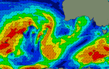
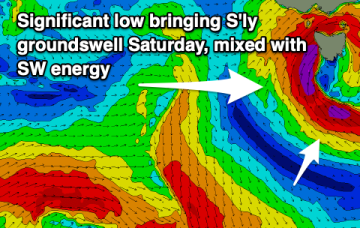
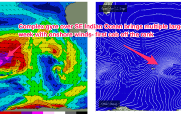
Into next week and very active Indian Ocean storm track spawns a slow moving massive gyre with multiple (at least 3) back to back to back severe gale fetches which will generate L to XL surf, primarily benefitting the NW and Indonesia. SW WA will be mostly in the storm track and thus subject to a mostly stormy, onshore flow, with the breaks between onshore episodes unlikely to be sufficient for surf to clean up away from a few select winter spots.

Plenty of strong S swell on the radar for next week

freeride76

Plenty of strong S swell on the radar for next week

freeride76

The headline act is a complex low system approaching Tasmania with an embedded front and linked to a long inland trough. A NE infeed into this system is producing swell from that quarter today and as the low clears the swell shadow of Tasmania we’ll start to see swells from the S. Following systems next week look to generate stronger, longer period S’ly swells.

Mixed bag of E/NE swell with developing S swell over the weekend and juicier S swells next week

freeride76

Mixed bag of E/NE swell with developing S swell over the weekend and juicier S swells next week

freeride76

The headline act is a complex low system approaching Tasmania with an embedded front and linked to a long inland trough. A NE-E/NE infeed into this system is producing swell from that quarter today and as the low clears the swell shadow of Tasmania we’ll start to see swells from the S. Following systems next week look to generate stronger, longer period S’ly swells.

Fun sized S swells this weekend, getting juicier next week

freeride76

Fun sized S swells this weekend, getting juicier next week

freeride76

The headline act is a complex low system approaching Tasmania with an embedded front and linked to a long inland trough. A NE-E/NE infeed into this system has produced swell from that quarter and as the low clears the swell shadow of Tasmania we’ll start to see swells from the S. Following systems next week look to generate stronger, longer period S’ly swells.

Another round of chunky NE swell ahead with plenty of S swell next week

freeride76

Another round of chunky NE swell ahead with plenty of S swell next week

freeride76

A front and small low are now racing across the Tasman with a high over NSW moving into the Tasman and directing a freshening N’ly flow across most of the Eastern Seaboard down to Tasmania. So far, so spring. A complex low, front and trough then approaches from the W, bringing a strong regime of W’ly-SW’ly winds and a series of S swells.

A few workable options amongst N'ly winds with a better outlook for strong S swells next week

freeride76

A few workable options amongst N'ly winds with a better outlook for strong S swells next week

freeride76

A front and small low are now racing across the Tasman with a high over NSW moving into the Tasman and directing a freshening N’ly flow across most of the Eastern Seaboard and a developing tradewind flow. So far, so spring. A complex low, front and trough then approaches from the W, bringing a flush of W’ly winds and a S swell.