Winter beachy options

Victorian Surf Forecast by Craig Brokensha (issued Wednesday 6th July)
Best Days: Today, Sunday on the beaches, Monday on the beaches for the keen but windy
Features of the Forecast (tl;dr)
- Easing mid-period S/SW swell this afternoon and further tomorrow with fresh W/NW tending strong SW winds
- Moderate sized SW-S/SW windswell for Fri with strong SW winds
- Easing SW windswell Sat with some inconsistent, small mid-period SW swell. Moderate S/SE winds, possibly becoming lighter through the day
- Slightly better, inconsistent mid-period SW swell Sun with N/NE tending NE winds
- Easing SW swell Mon with strong N/NE winds
- Small Tue with W/NW tending W/SW winds
Recap
Poor waves across most locations yesterday with a gusty onshore S/SE wind on the Surf Coast and 2ft of swell, bumpy and average across the Mornington Peninsula. Phillip Island saw lighter winds and cleaner conditions but today is much better.
A fun pulse of new mid-period S/SW swell has filled in roday under light offshore winds. The Surf Coast is 2-3ft and peaky with some localised windswell left in the mix from yesterday's blow, while the Mornington Peninsula is clean and straight to 4ft+ on the sets. Winds should hold all day as the swell eases.
This week and weekend (Jul 7 - 10)
Today is one of the days of the period so make the most of it. Winds will remain favourable all day for the beaches as the current S/SW swell eases.
 Tomorrow will be smaller and winds will shift to the W/NW ahead of a tough and strong afternoon SW change.
The Surf Coast will be clean in the morning but a small 1-2ft.
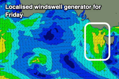
This trough is a touch stronger than forecast on Monday but still weak when compared to a proper cold front and it'll generate some weak, localised SW-S/SW windswell for Friday to 3ft+ on the Surf Coast and 4-6ft to the east. Winds will be poor though and strong from the SW with little to no chance of early W'ly winds west of Melbourne. Even if they did swing that way the swell will be weak and poor in quality.
The windswell will ease through Saturday under S/SE winds as high starts to move in from the west. There might be a period of more variable winds through the day but again the swell will be low in quality.
There should be some inconsistent, mid-period SW swell in the mix Saturday and more so Sunday morning, generated by a distant but healthy polar frontal progression to the south-west of Western Australia the last two days.
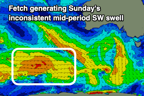 This should provide 2ft waves on the Surf Coast Saturday with 3-4ft sets to the east, a touch stronger Sunday morning to 2ft to possibly 3ft west of Melbourne, 3-5ft to the east.
Conditions look great for the beaches with a light N/NE tending NE breeze, well worth a surf.
Moving into next week, the weekend's mix of swells will be on the ease and stronger N/NE winds will create tricky conditions.
The strengthening winds will be linked to an approaching series of strong but weakening mid-latitude fronts up and across Western and South Australia. They'll not be great for swell generation at all, with small levels of acute W'ly swell due mid-late week but with deteriorating SW-S/SW winds in the wake of the activity. There's still no major Southern Ocean frontal activity on the radar but check back Friday and next week for further updates.
Comments
In 30+ years of surfing we just came through worst summer i can remember and now winter is not looking a whole lot better. Few scattered good days here and there no doubt, but this time of year normally surfing 4 to 5 times a week
Might be time to hang up the boots
Yep, your right. And what swell there is usually got far too much west in it. I watched winki this morning and there were 3 swells from different directions moving through the lineup. One or two turns then close out. Those high-pressure cells are doing a really good job of blocking any approaching lows that have the potential to generate swell (from the right direction) into our window.
Yes. I was watching on surf cam.
Yes PL, I couldn't agree more. You forgot to mention a well below average Autumn as well. I hope this is not the new normal for the Surf Coast.
I have hardly surfed at all this Autumn and early Winter 2022 . The conditions are simply not there whereas in the past one could camp out near one's preferred spot and surf for three days straight in good surfing conditions. It made a good case for having three wetsuits and multiple pairs of booties!
:-(
Plenty of snow top-ups coming Mr T.
Craig have you got a stat mate for which coastline complains, bemoans, winges, whines and generally carries on loudest re: lack of quality swell in the forecast?
I'm sizing up various mammals I come across as potential sacrificial offerings
Best to let it out rather than bottle it up.. Surfcoast will have it’s time again, we all know that but it’s been a pretty frustrating coupla years in and out the water. All it takes is a run of a week or two and all is forgotten. You on the MP?
Ahhh see , I feel slightly better already.
Fun waves today, sun was out and really quiet. I’ll take it.
Great to hear :)