Lots of swell to work around, cleanest ahead of Wednesday

Victorian Surf Forecast by Craig Brokensha (issued Friday April 29th)
Best Days: Sunday Surf Coast, Monday, Tuesday, Wednesday morning Surf Coast
Features of the Forecast (tl;dr)
- Weak W/SW swell building tomorrow with a stronger, inconsistent groundswell arriving late. Strengthening W/NW winds, shifting W/SW into the PM
- Inconsistent W/SW groundswell peaking Sun AM, easing through the day with mod-fresh NW tending lighter W/NW winds
- N/NW winds Mon (tending N into the PM east of Melbourne)
- Late pulse of W/SW and SW groundswells Mon, peaking Tue AM, easing through the day
- Strengthening N tending N/NW winds Tue
- Moderate sized mix of mid-period and long-period swell building Wed PM with W tending fresher SW winds
- Large mix of swells Thu AM, easing through the day with gusty S/SW winds, easing further Fri with S winds
Recap
Small to tiny surf across the Surf Coast yesterday with fun waves on the exposed beaches to 2ft, similar today with some small, background swell.
This weekend and next week (Apr 30 - May 6)
The coming weekend will see the surf slowly building in size and power as a mix of westerly swells fill in, firstly tomorrow mostly weak and small ahead of a better W/SW groundswell on Sunday.
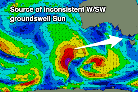 The source of these swells is the same system, with a strong, slow moving polar low firing up initially towards Western Australia, generating Sunday’s inconsistent groundswell, with the low weakening while pushing east and towards us today and tomorrow.
The remnants of the low will move through tomorrow bringing some weak W/SW swell ahead of the late arrival of the groundswell which should peak Sunday morning.
Winds will favour the Surf Coast as the fronts/low push across us with a strengthening W/NW breeze tomorrow morning, shifting W/SW into the afternoon and weak 1-2ft waves during the morning west of Melbourne, building to 2-3ft by later in the day. To the east there’ll be more size but poor conditions.
Now, the fetch linked to Sunday’s swell was just within our western swell window, but with it being a little flukey expect inconsistent sets and a wide range of sizes as it peaks. The Surf Coast should generally be around 3ft but expect inconsistent 4ft to possibly 5ft sets at times on the magnets through the morning, easing steadily during the day. The Mornington Peninsula should come in around 6ft+ and a moderate to fresh NW tending weaker W/NW breeze will favour protected spots.
The groundswell will be gone Monday with weaker mid-period W/SW energy due in its wake, coming in at 2-3ft mostly on the Surf Coast and 4-5ft to the east. Conditions look to improve for selected locations east of Melbourne with a N/NW tending N breeze on Monday, holding N/NW all day on the Surf Coast.
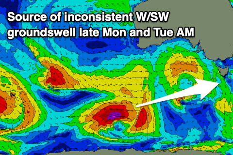 Now, later in the day some new, W/SW and SW groundswell are expected, with the first generated by a small low generating a fetch of W/NW gales to the south-west of Western Australia this evening and tomorrow. The low will weaken while passing under the country Sunday. An additional SW groundswell will be generated by a stronger, but tight and small polar low forming south-southwest of Western Australia today.
Both swells look to be a similar size, peaking Tuesday morning to an inconsistent 3-5ft on the Surf Coast magnets, 6ft+ to the east. Winds look favourable for both regions, strengthening from the N’th east of Melbourne before shifting strong N/NW, with N-N/NW winds persistent across the Surf Coast all day ahead of a shallow W’ly change Wednesday morning.
The change will be associated with a significant frontal progression that will fire up and under the country, weakening on approach to us, with a moderate to large W/SW groundswell due from this source on Thursday.
The frontal progression has already started its life as a strong polar low west of the Heard Island region (in our far far swell window), with a fetch of severe-gale to storm-force winds due to weaken as the low moves slowly east.
It’ll continue to generate W/SW gales before breaking down while projecting up and into the Bight Monday evening and Tuesday.
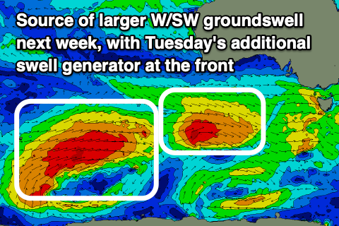 The end result will be a very long-period groundswell mixed in with slightly lower period swell energy, arriving Wednesday afternoon, peaking Thursday morning. Building sets to 4ft+ are due on the Surf Coast into the later afternoon Wednesday, 6ft+ to the east but with SW winds as a trough and then high start to move in behind the morning W’ly.
Thursday will see larger sets to 6ft across the Surf Coast, 8ft to the east but as the high moves in further, gusty S/SW winds will spoil most locations, S’ly Friday as the swell eases. The onshore wind depends on the positioning of a trough, so if it stalls we could see lighter winds, though we'll have to check this next week.
Unfortunately it looks like we’ll see SW-S winds persisting into next weekend owing to a possible low forming off the southern NSW coast, stalling the encroaching high. This will cut off the supply of swell with easing size due into next week as winds slowly shift more east. More on this in Monday’s update though. Have a great weekend!
Before you go - Tim Bonython's Australian Surf Movie Festival is coming up real soon (first week of May), with incredible new 8K footage of Nazaré, Jaws, Mavericks, Teahupo’o and more, that simply HAS to be seen on the big screen. Get your tickets to the shows in Geelong, St Kilda and Rosebud here: https://swllnt.com/3v2MlNc
Comments
Good News. Thanks Craig.