Slow improvement in winds as the size eases next week

Victorian Surf Forecast by Craig Brokensha (issued Friday 28th January)
Best Days: Sunday morning keen surfers to the east, Monday mid-late morning to early afternoon to the east, Tuesday morning
Features of the Forecast (tl;dr)
- Mod-fresh S winds with small to tiny surf tomorrow
- Inconsistent building W/SW groundswell Sun with mod-fresh SE tending stronger SE winds (winds tending E/SE at periods to the east through the AM)
- Easing W/SW groundswell Mon with light E tending S/SE winds
- Smaller mix of easing W/SW swell and reinforcing S/SW swell with N/NE tending N/NW winds ahead of a strong S/SW change mid-afternoon
- Poor surf and gusty S winds for the rest of the week
Recap
Some great weather and storm watching over the past 24 hours (with more action moving in as you read). The broad trough with two embedded lows that was sitting west of us, across the Bight through the week finally started moving in Wednesday evening and more so through yesterday bringing volatile and dynamic weather with tropical downpours and plenty of lightning.
A small S/SE windswell provided clean 2ft peak down the southern half of the Surf Coast yesterday, 1-2ft on the Mornington Peninsula with clean conditions on the beaches.
Today there's some inconsistent background SW swell with the S/SE energy fading and conditions are clean but full ahead of a trough and S/SW change which is moving through now.

Small bumps with the change just moving through
This weekend and next week (Jan 29 – Feb 4)
The shallow S/SW change currently moving through is associated with the backside of the trough and weather as it continues east, followed by a strong high moving in behind it from the west.
This will bring stabilising weather and moderate to fresh S'ly winds tomorrow along with a continuation of small to tiny surf.
As the high continues further east under us Sunday winds should swing around to the SE, with the Mornington Peninsula and Phillip Island likely seeing winds tend more E/SE at times during the morning.
We'll see our inconsistent W/SW groundswell filling in through the day, with the low that was linked to it breaking down south of Western Australia yesterday.
There'll be a wait for the sets and a peak is due into the afternoon but the Surf Coast should see 3ft to occasionally 4ft waves on the magnets with building surf to 5-6ft on the beaches to the east. The morning looks to be an inconsistent 2-3ft and 4ft+ respectively across the Surf Coast and Mornington Peninsula when those winds are best, while the afternoon will see stronger SE winds kick in.
Monday will see conditions slowly improving as approaching trough/low from the west pushes the high further east, swinging winds to a light E'ly. This isn't as favourable as forecast on Wednesday with plenty of lump and wobble likely to be seen in the morning, improving and likely best midday/early afternoon before sea breezes kick in.
 Sunday's swell will be easing, dropping from an inconsistent 3ft on the Surf Coast and 4-5ft to the east.
Tuesday looks nice and clean through the morning with moderate N/NE tending N/NW winds ahead of a strong S/SW change mid-afternoon as the trough/low pushes in from the west.
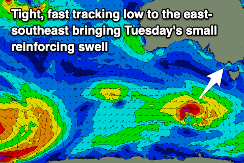
Size wise the swell will be smaller than Monday but steadying with a small, reinforcing S/SW swell generated by tight, strengthening low tracking east-southeast through our swell window on the weekend. This looks to maintain 2ft+ waves on the Surf Coast and surf to 4ft on the Mornington Peninsula, best ahead of the change.
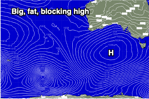 Tuesday afternoon's change will signal the arrival of the eastern edge of a strong, broad and slow moving high moving into the Bight, squeezing with a trough off the East Coast, resulting in a poor run of winds and surf from Wednesday through the following Tuesday.
Strong S/SW winds on Wednesday will slowly shift anti-clockwise through the end of the week and weekend along with poor levels of S'ly windswell. More favourable E/NE winds are due into the following week but with little in the way of groundswell. More on this Monday. Have a great weekend!
Comments
Incredibly sharp with the early morning report today craigos! Hats off
Thanks Tubba.
It has been a doozy of a change.
Zzzz I new I should have moved to NSW last year
That lightning cell that came over about 8:30 Thursday was incredible. I was caught taking out neighbours' bins. What struck me was just how low -and fast- the cloud was with the initial burst and wind - and how strong the rain was, big drops too. Like the 120/kmh windstorm some months ago, Huey tends to send 'em for bin Friday...
Best lightning show in ages here, too. Very close.
Buoys have moved much
Sooo west
And now tomorrows winds have gone wsw. We just can’t win this year
Aghh, yeah trough moving in quicker. Bummer.
Heard the swell kicked in nicely through yesterday afternoon on the exposed beaches as forecast.