Make the most of the coming windows of waves

Victorian Surf Forecast by Craig Brokensha (issued Wednesday 13th October)
Best Days: Tomorrow morning, Friday Surf Coast early-mid afternoon, keen surfers Sunday morning Surf Coast, Tuesday morning on the beaches
Features of the Forecast (tl;dr)
- Inconsistent W/SW groundswell with local offshore winds (N'ly bias) ahead of a Sly afternoon change
- Easing W/SW groundswell Fri with fresh-strong SW tending W/NW-NW winds into the afternoon, then SW late again
- Mix of inconsistent SW groundswell and S/SW windswell Sat with strong SW winds, easing Sun with fresh SW winds (possibly W'ly early on the Surf Coast)
- Small mid-period S/SW swell for Mon PM with N/NW tending W/NW then S winds, easing Tue with E/NE tending SE winds
Recap
The swell seen through Sunday and Monday continued to ease back in size through yesterday with improving conditions on the beaches under an E/NE tending N/NE breeze. The Mornington Peninsula eased from 3ft to occasionally 4ft, and winds remained favourable all day, tending variable late.
Today there's no size left with tiny, full waves across most locations, up to 1-2ft down the Surf Coast out of the S/SE.

Shapely peaks out of the south-east down the Surf Coast this AM
This week and weekend (Oct 14 - 17)
With the swell bottoming out today, we look to our new, inconsistent W/SW groundswell due tomorrow across the state.
This swell was generated by a strong frontal progression that formed around the Heard Island region over the weekend, projecting W/SW gales up towards Western Australia through our western swell window.
The front then spawned into a low pressure system in the Bight, pushing the swell generating fetch too far north and out of our swell window. As a result we'll be relying on the initial stages of the frontal progression, so the swell will be a bit inconsistent.
The Surf Coast should see 3ft sets across the swell magnets with 4-6ft sets to the east and conditions are looking favourable through the morning with local offshore winds (but with a northerly tendency). The Surf Coast should see light to moderate N/NW winds, N/NE-N to the east, giving into S'ly change through the afternoon.
Friday is a tricky one as we're expected to see the low move in from the west, with the axis moving right across us. This will bring varying winds which look poor through the morning and fresh to strong from the SW, shifting W/NW-NW into the afternoon but then back to the SW late.
So with this the Surf Coast will be the best working the window of offshore winds, but the swell will be on the east from tomorrow, likely dropping from the 2-3ft range.
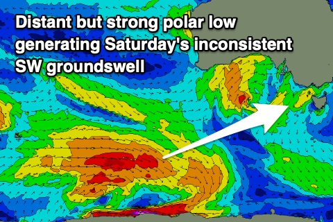 The weekend is still looking generally poor with the low due to restrengthen off the Tasmanian coast during Saturday, bringing strong SW winds on its western flank which will blow through Bass Strait.
This will kick up a moderate sized S/SW windswell on Saturday, mixed in with a new, inconsistent and stronger SW groundswell. As touched on in Monday's update, this groundswell has been generated by a strong but distant polar low over the last two days around and east of the Heard Island region. The low is currently weakening, with inconsistent surf to 3ft+ on the Surf Coast and 4-6ft to the east due Saturday, easing Sunday from a similar if slightly smaller size. The localised windswell looks to be a little larger in size, also easing Sunday as winds ease but persist from the SW. There's an outside chance for early W'ly winds around Torquay for keen surfers.
Next week onwards (Oct 18 onwards)
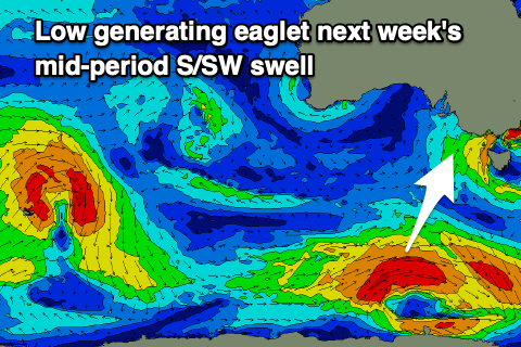 We'll see conditions improve through early next week across the state, but winds on Monday now look to have a N/NW tending W/NW bias as a weak trough moves through, bring an afternoon S'ly change. This will favour the Surf Coast as a new, mid-period S/SW swell fills in.
The source of this swell will be a small polar low developing under the country Friday, generating a fetch of W/SW gales through our swell window before weakening Saturday evening.
Size wise it looks to come in at 2-3ft on the Surf Coast with 4ft+ sets to the east on Monday afternoon, easing through Tuesday from a similar if not slightly smaller size. Winds should swing around to the E/NE on Tuesday morning as the trough clears, more NE on Wednesday but with no decent size.
Longer term there's nothing significant on the cards, so make the most of coming waves.
Comments
Is that the best wave that’s ever com through at Fairhaven and just so happened to be caught on camera?
Best I've seen, actually hollow, ha!
That camera angle can be so deceiving for swell height. I watched but didn’t surf it was barely knee high and barely enough push for a log.
was very gutless
Ha, that set is bigger than that on the cam. Looked a fun 2ft.
Today was basically rubbish at Fairhaven. It can get very good with a decent SE swell and Northerly wind, but is rare and drops off quickly. It can get a good bank for a SW swell on rare occasions too.
Yep Fairhaven was looking like a miniature superbank
I wish 1foot windswell looked like a super bank to me
Here this may help
Haha.
Poket, why post photos? Discretion the better part of valour, etc.....
Why not? It was a one off swell that wasn't even surfable at the most visible beach on the whole surfcoast...sheesh!
Gave me a giggle. Nice work Poket.
The swell was a bit behind schedule but there are some better sets now..
Wha?
You must have missed that 10 minute window Nick.
I enjoyed my window. Im just curious as the cam looks like real rough water colour paper!
What a trip haha.