Get stuck in today and tomorrow morning

Victorian Surf Forecast by Craig Brokensha (issued Friday 8th October)
Best Days: Today, tomorrow on the exposed beaches, Tuesday on the beaches, Thursday Surf Coast, Friday Surf Coast
Features of the Forecast (tl;dr)
- Easing mid-period W/SW swell tomorrow with local offshore winds ahead of a late afternoon S/SW change
- Building mix of inconsistent W/SW groundswell and mid-period swell Sun with strengthening SW tending S/SW winds, easing Mon with strong S/SW-S winds, easing and tending S/SE
- Easing swell Tue with E/NE tending N/NE winds ahead of late SE sea breezes
- Low point in swell Wed with fresh N/NE winds
- Moderate sized W/SW groundswell Thu with NW tending W/SW winds, with a secondary reinforcing pulse for Fri
Recap
Poor conditions yesterday with a cold front pushing through along with a low point in swell, while today is much better with our second pulse of mid-period swell for the week filling in and peaking, offering 2-3ft sets on the Surf Coast and 4ft waves to the east. Conditions are favourable across most locations and will remain so into the afternoon.

Improving options this AM
This weekend and next week (Oct 9 - 15)
Make the most of today as we'll see the swell starting to ease into this afternoon, smaller tomorrow but still clean and fun across exposed breaks.
Size wise, slow 2ft sets are due on the Surf Coast tomorrow morning, 3ft+ to the east (easing through the day) with light, local offshore winds with a northerly tendency, remaining so ahead of a late afternoon S/SW change.
This change will be related to a weak trough moving in from the west, followed by a stronger system on Sunday, bringing fresh SW-S/SW winds, strengthening through the day.
With a low point in swell through early Sunday morning, there's nothing to recommend.
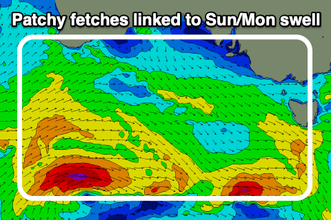 Into the late morning/afternoon a mix of long-range W/SW groundswell and mid-period energy are due to fill in. The long-range energy was generated by a strong but patchy polar low firing up east of the Heard Island region during the middle of this week, while the remnants of this low has since pushed east towards us, generating weaker, patchy fetches of strong to gale-force W/SW winds.
Both swells should build through the day and reach 3ft+ across the Surf Coast through the afternoon, 4-5ft+ to the east but with that strong S/SW breeze.
A high will move in on Monday, swinging winds to the S'th, still gusty in the morning, easing and tending more S/SE through the day. We should see the swell easing back from the 3ft range on the Surf Coast, 4-5ft on the Mornington Peninsula, but there might still be the odd bigger one in the mix at times across both regions.
Tuesday is still looking the day to surf, with smaller, easing waves but more favourable E/NE tending N/NE winds ahead of late sea breezes. This will be as the high moves further east, pushed by a strengthening cold front/low in the Bight.
Size wise, the Surf Coast looks to ease from 2ft, with 3ft to possibly 4ft sets to the east.
Now, the cold front/low pushing in through the Bight will start its life just north of the Heard Island region tomorrow evening, projecting slowly east-northeast through our western swell window while generating a gale-force fetch.
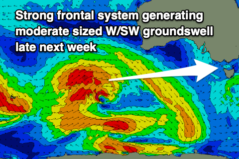 This should produce a moderate sized, W/SW groundswell for Thursday, but we'll see a reinforcing pulse for Friday as the frontal progression stalls in the Bight and forms into a low on Tuesday evening, producing a stationary fetch of strong to gale-force W/SW winds.
With the low stalling, winds on Wednesday will remain favourable for the beaches and strong from the N/NE but the swell will be minimal and to 2ft or so, tiny on the Surf Coast.
Thursday's swell should provide inconsistent 3ft sets on the Surf Coast magnets, 4-6ft to the east and with W/NW-S/SW winds. Friday looks similar if not a touch stronger but with N/NW tending stronger W/NW winds. We'll take a closer look at this Monday though. Have a great weekend and enjoy today!