Great swells and surf this week

Victorian Surf Forecast by Craig Brokensha (issued Monday 6th September)
Best Days: Tomorrow ahead of the change, Wednesday, Thursday, Friday, Saturday, Sunday morning
Features of the Forecast (tl;dr)
- Mod-large SW groundswell building tomorrow, with a larger, close-range SW swell added to the mix into the mid-late afternoon. Moderate W/NW tending mod-fresh SW winds
- Large, easing S/SW groundswell Wed with fresh N/NW-NW winds
- Smaller Thu with strong N/NW tending W/NW winds
- Moderate sized, mid-period SW swell filling in Fri with N/NW tending N/NE winds
- Easing SW swell Sat with strong N/NW tending W/NW winds
- New S/SW groundswell Mon with S winds
Recap
Friday's initial onshore change was only short-lived and we saw good conditions persisting into the afternoon as winds eased and went variable. Overnight though, we saw the high pressure ridge edging in from the west, bringing average, fresh S'ly winds which strengthened from the S/SW through the day.
Yesterday remained poor with onshore winds and a moderate sized W/SW groundswell. Today conditions are still poor owing to strong Southern Ocean frontal activity skiting up past the south-east corner of the high. One of these fronts has moved through today bringing a localised, weak SW windswell.
This week and weekend (Sep 7 - 12)
After a few poor days of surf we've got some excellent surf on the cards for the coming period.
Firstly today's spike in local windswell from a strong cold front pushing up through Bass Strait will ease into tomorrow, with a low point in swell expected. We're talking 2ft Surf Coast and 3-4ft to the east, likely the smallest it'll be for a while.
It won't stay small for long, as a new, inconsistent long-period SW groundswell starts to build from mid-morning, generated by a strong, slow moving polar low that developed around the Heard Island region last Thursday evening.
This swell should build to an inconsistent 4-5ft+ through the afternoon, with 6ft to possibly 8ft sets to the east, but the secondary, reinforcing close-range swell that was expected to be a touch smaller, now looks to top this groundswell.
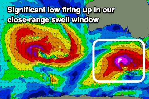 The source of this swell is a strong, tight low forming on the back of the initial polar system, generating a fetch of severe-gale to storm-force W/NW tending W/SW gales through our close-range swell window today and tomorrow.
Mid last week this storm was due to be significant, but Friday's model updates downgraded it, but alas we've had a fresh upgrade and we're now due to see a large, long-period SW groundswell from this source, kicking strongly late tomorrow, peaking overnight and easing from the S/SW Wednesday.
Strong 6ft sets are due later tomorrow on the Surf Coast with 8ft surf to the east, but a morning W/NW breeze will shift moderate to fresh SW early afternoon. Overnight larger surf is likely, but peaking under the cover of darkness.
Wednesday is the day with fresh, persistent NW-N/NW winds and easing 5-6ft waves on the Surf Coast, 6-8ft to the east.
Stronger N/NW winds are due Thursday, shifting W/NW into the afternoon along with a further drop in size, easing 2-3ft on the Surf Coast and 4ft+ to the east.
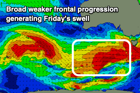 Later in the day but more so Friday, some new, mid-period SW swell is expected, generated by a strengthening, broad polar frontal progression firing up under the country Wednesday afternoon.
Strong to gale-force W-W/SW winds are forecast and this should produce a moderate sized swell, building through Friday and reaching 3-4ft on the Surf Coast with 5-6ft sets to the east. There might be the rare bigger sneaker at times during the peak of the swell. Winds are interesting Friday and will improve for the beaches through the day with a light, morning N/NW breeze, tending N/NE into the afternoon.
Winds look to shift back to the N/NW tending W/NW on Saturday as the mid-period SW swell eases, though still 3ft on the Surf Coast and 4-5ft to the east.
Yet another swell is likely on Sunday/Monday but winds look to deteriorate as a trough spawning off the polar front linked to the swell moves through. More on this in Wednesday's update though.
Comments
I am ready, again.
Way more reliable this time Ed.
All this good surf will vanish by the time I am allowed out of Loch Doon. :-(
Lotta locals out at lorne point this afternoon