Get stuck in before the onshore winds hit

Victorian Surf Forecast by Craig Brokensha (issued Monday 23rd August)
Best Days: Selected breaks Thursday, Friday morning on the beaches, Saturday morning on the beaches
Features of the Forecast (tl;dr)
- Moderate sized + W/SW groundswell tomorrow but with strong S/SW-S winds
- Easing W/SW groundswell Wed with strong S winds
- Moderate sized SW groundswell kicking late Wed, peaking Thu with fresh S/SE tending weaker SE winds, freshening again into the PM
- Easing SW groundswell Fri with E/NE tending fresh SE winds, smaller Sat with NE tending SE winds
- Inconsistent, small W/SW groundswell Mon with gusty N/NW winds
Recap
A low point in swell was seen Saturday morning across the state with clean conditions for the Surf Coast. Into the afternoon a very inconsistent W/SW groundswell provided a touch more action across the magnets with 2ft+ sets.
A slightly more consistent though still smallish mid-period W/SW swell filled in yesterday providing similar sized surf, with better options opening up on the beaches as winds tended more N/NW. The Mornington Peninsula offered fun ones across selected breaks.
Today there is a touch more size again with a slightly stronger, inconsistent W/SW groundswell in the water, coming in at 2-3ft on the Surf Coast though cleanest in protected spots, bigger to the east but choppy. Make the most of the clean conditions as winds will shift onshore into the afternoon, not returning back to the north-eastern quadrant until Friday.
This week and weekend (Aug 24 - 29)
Currently the remnants of a strong polar low, come mid-latitude front and now trough are pushing in from the west, and while bringing a strong new W/SW groundswell for tomorrow, it'll also bring poor conditions and winds.
The trough is due to form into a very intense low off the southern NSW coast tomorrow, and its slow movement and stalling nature off the East Coast will extend persistent onshore winds out of the south across our coasts.
Coming back to the groundswell generated by the initial stages of the storm, and we should see this swell fill in overnight and offer inconsistent but strong 4-5ft sets on the Surf Coast swell magnets tomorrow morning (expect mostly 3-5ft surf), 6ft to occasionally 8ft on the Mornington Peninsula, easing into the afternoon.
Winds will be strong out of the S-S/SW all day tomorrow, leaving only a couple of decent surfing options. The swell will ease through Wednesday as strong S'ly winds persist, owing to the stalling nature of the low to our east.
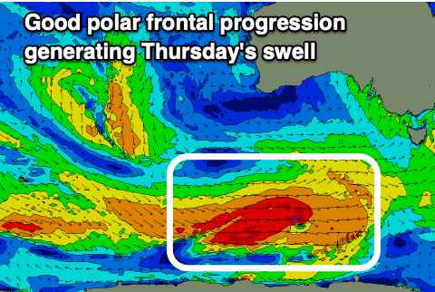 Into Wednesday afternoon and more so Thursday a good new SW groundswell is due, generated by a polar frontal progression firing up under the country over the coming days.
Good fetches of W-W/SW gales will be generated through our south-western swell window, producing a moderate sized SW groundswell that should build later Wednesday but peak through Thursday.
The Surf Coast should see good 3-5ft surf on the swell magnets, 5-6ft+ to the east but with moderate to fresh S/SE tending lighter SE winds through the morning, stronger into the afternoon again.
At this stage, Friday still looks the pick with winds shifting E/NE through the morning along with easing S/SW swell from 3ft+ on the Surf Coast and 4-5ft to the east. The afternoon looks bumpy with gusty SE winds kicking back in.
 We'll see the surf fading in size and power on the weekend as winds continue to slowly improve, swinging NE Saturday morning ahead of SE sea breeze, but there doesn't look to be much size left.
The Surf Coast will be fading from 2ft, 3ft or so to the east, tiny Sunday under stronger N/NE winds.
Next week onwards (Aug 30 onwards)
It looks like we'll see a run of small surf continuing into mid next week owing to the slow movement of a blocking high pushing in from the west later this week and weekend.
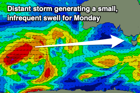
 With this we'll have to rely on long-range, inconsistent swell energy, with one such swell due out of the W/SW Monday. It'll be produced by a strong polar low firing up around the Heard Island region tomorrow, projecting W/SW gales through our far swell window (shown above right).
The Surf Coast looks to see infrequent 2ft+ sets, 3-4ft+ to the east along with gusty N/NW winds.
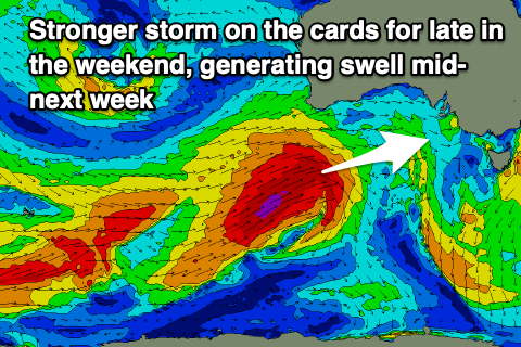
Following this a strong frontal progression is on the cards, producing a larger W/SW groundswell for mid next week, but we'll follow this over the coming updates.