Slower period as the frontal activity slows up

Victorian Surf Forecast by Craig Brokensha (issued Friday 30th July)
Best Days: Today on the beaches, beaches tomorrow morning, Sunday afternoon Surf Coast, Monday on the beaches
Features of the Forecast (tl;dr)
- Easing W/SW swell tomorrow with gusty N winds, shifting NW mid-afternoon
- Inconsistent W/SW groundswell building Sun, peaking into the PM with moderate NW tending lighter W/NW winds
- Easing mix of W/SW swells with strengthening N/NE winds
Recap
Yesterday’s second tricky westerly swell in a week came in as expected with waves ranging between 3-5ft on the Surf Coast, 6ft to occasionally 8ft to the east and with improving conditions across all spots. A morning W/NW breeze shifting more NW into the afternoon and this morning we’ve got gusty N’ly winds but an easing, inconsistent swell.
The Surf Coast is 3ft, with the odd 4ft’er on the magnets, with 4-6ft sets to the east. The swell will continue to ease through the day as winds hold from the N’th.
This weekend and next week (July 31 - Aug 6)
The current inconsistent westerly groundswell will continue to ease back in size and power into tomorrow, leaving infrequent 2ft to occasionally 3ft sets on the Surf Coast magnets with 3-4ft+ waves to the east. Winds will be gusty and out of the N’th again through the morning, shifting NW mid-afternoon.
Our new, inconsistent W/SW groundswell for Sunday is still on track, but with the large distance between the source of the swell, west direction and lack of size, it’ll be slightly frustrating. This swell was generated by a significant storm that formed just north-east of Heard Island, projecting a fetch of severe-gale W/SW winds up towards and across Western Australia. The swell from this in WA will be XL, but with the fetch being initially so far away from us, then pushing north of our swell window, only inconsistent sets are due once it pushes into Bass Strait.
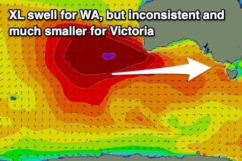 The swell will also build through the day and be a bit undersized early, building to an inconsistent 3ft on the Surf Coast swell magnets into the afternoon, 4-5ft+ to the east. This is under model forecasts through the morning especially, with the models incorrectly combinining existing energy with the new long-period forerunners.
Winds will be favourable all day, moderate from the NW in the morning, shifting W/NW and easing into the afternoon.
Monday looks much better on the beaches as the swell eases back from an inconsistent 2-3ft on the Surf Coast and 3-5ft to the east under strengthening N/NE winds.
Looking at the longer term outlook, and all the strong, mid-latitude frontal activity seen through the last couple of weeks will dissipate, with nothing too significant at all on the cards for the start of August. Instead we’ll be relying in small-moderate size, long-range swells, but more on this Monday. Have a great weekend!
Comments
So the Sam played out to the typical 2 week period interesting stuff.
Might need a better satellite to predict this unpredictable weather. What was that, 2 long wave troughs since Sept/October last year?
Does that purple blob on the WAMS for next Thursday/Friday mean some promising surf for us on the horizon or too early to tell/other factors will affect it?
Considering how wobbly the isobars look in the low on Thursday night and the size of the high dominating mainland Oz. Not looking good
Bugger, ill keep the expectations lower.
thanks poo man