Fun waves across all locations for the coming period

Victorian Surf Forecast by Craig Brokensha (issued Monday 17th May)
Best Days: Tuesday, Wednesday morning Surf Coast, Friday through Monday on the beaches
Features of the Forecast (tl;dr)
- Easing S/SW groundswell tomorrow with moderate NW winds, smaller Wed with fresher N/NW winds
- Poor Thu with an increase in swells for the PM but with a S/SW change
- Better Fri as the swell peaks along with light N/NE tending variable winds
- Easing surf moderate N tending N/NE winds
- New W/SW swell building Sun with fresh N/NE winds, easing Mon with strong N/NE winds
Recap
Windy, average waves across the state Saturday with plenty of swell, much better yesterday with cleaner conditions under strong NW tending W winds.
This week and weekend (May 18 - 23)
Coming in cold off a couple of weeks break it looks like there's a good new S/SW groundswell on the build today which Ben talked about the last couple of updates.
This groundswell was generated by a strong polar low firing up over the weekend and we'll see it peaking this afternoon but with those onshore SW winds.
Tomorrow is looking much better as the swell eases out of the S/SW and winds shift back to the NW, moderate through the morning and more variable into the afternoon, tending N'ly late east of Melbourne. The swell should still be chunky, easing back from 4-5ft on the Surf Coast swell magnets, 6ft+ to the east.
 Wednesday will be smaller but a fresher N/NW breeze will continue to favour the Surf Coast and a couple of selected spots to the east as the size drops back to 2-3ft on the Surf Coast and 4ft to the east.
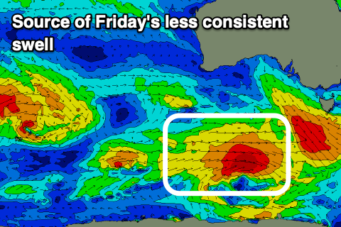
Into the end of the week we've got a couple new swells on the cards, the first being longer-period and inconsistent out of the W/SW-SW, backed up by a more consistent, close-range W/SW groundswell as a tight, intense low fires up directly south-west of us.
The close-range swell will likely be just under the size of the longer-range energy with a tight low that's currently east of Heard Island due to dip south-east and broaden tomorrow, generating a healthy fetch of W/SW gales in our south-western swell window.
Both swells are due to build Thursday afternoon but peak Friday with fun 3ft+ sets due on the Surf Coast, 4-6ft on the Mornington Peninsula.
With a gusty N/NW offshore in the morning Thursday and minimal swell, giving into a S/SW change into the afternoon it looks like a lay day but Friday looks much cleaner with winds shifting quickly back to the N/NE, becoming variable into the afternoon. This will be the start of a more favourable run for the beaches as high pressure ridges move in slowly from the west bringing persistent northerly winds.
Friday's swells will ease into Saturday as winds hold out of the N'th, likely better across the Mornington Peninsula into the afternoon as they tend lighter N/NE.
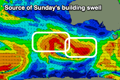 Fresher N/NE winds are due Sunday along with a new mid-period W/SW swell, generated by a healthy fetch of pre-frontal W/NW winds and then post-frontal W/SW winds pushing under the country late week.
The swell looks to build through the day and peak into the afternoon with good sets to 4ft+ on the Mornington Peninsula, mostly 2ft on the Surf Coast with the odd 3ft'er on the swell magnets.
Monday should remain clean but winds will strengthen from the N/NE ahead of a cold front, creating tricky conditions.
Longer term there's a fun mid-period W/SW swell for next week from the front moving in Tuesday, but we'll have a closer look at this Wednesday.