Good few days ahead

Victorian Surf Forecast by Craig Brokensha (issued Wednesday 3rd February)
Best Days: Beaches Thursday, Friday, Saturday Surf Coast
Features of the Forecast (tl;dr)
- Easing SW swell tomorrow with E/NE tending NE winds
- Strong, inconsistent SW groundswell for Fri with strong N/NE winds, tending S/SW late afternoon, easing Sat with NW winds, tending S/SW late afternoon
- New SW groundswell for Mon but with fresh S'ly winds, easing Tue/Wed as winds improve for the beaches
This week and next (Feb 3 - 12)
After the last few days of onshore winds, we’ve got a much better outlook on the cards for the coming days as a cold front projecting up through the Bight forms into a low and stalls, directing persistent winds out of the northern quadrant across us until it finally moves east Saturday evening.
 Today’s mix of swells will ease back through tomorrow, dropping from 2ft+ on the Surf Coast swell magnets and 3-4ft to the east and winds will swing around to the E/NE, shifting more NE late morning and likely holding into the evening. This will favour the beaches all day.
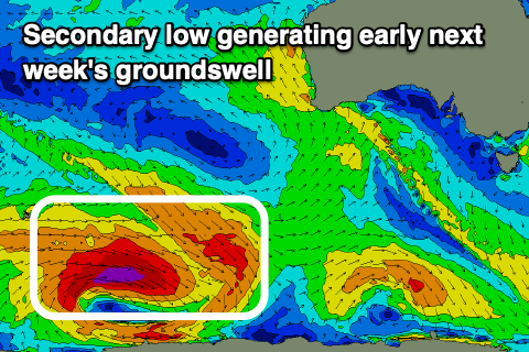
Moving into Friday and we’ll see our new, long-period but slightly inconsistent SW groundswell filling in. The source of this swell was a strong polar low firing up south-west of Western Australia the last couple of days, with a great fetch of severe-gale to storm-force W’ly winds projected towards us.
The low is now weakening and splitting, leading to that front pushing through the Bight, with the groundswell due to peak Friday with inconsistent sets to 3-4ft+ on the Surf Coast and 5-6ft+ to the east. With the low in the Bight pushing a little closer, winds will strengthen from the N/NE, giving into a late afternoon, shallow S/SW change. Winds should then veer around to the NW Saturday (fresh) as the SW groundswell eases back from 3ft and 4-5ft respectively. Another late afternoon change is due but this will be more significant, leaving SW winds into Sunday ahead of a new SW groundswell through the afternoon but more so Monday.
 As touched on in Monday’s notes, this second pulse of long, period SW groundswell looks similar to Friday’s, though likely a little less consistent and a touch smaller. The low linked to it is a touch more distant and smaller in scope but we’ll still see a generous fetch projected through our south-western swell window today and tomorrow. Weaker trailing fronts will also soften the easing trend after the swell peaks.
The swell is due later Sunday, peaking Monday with inconsistent 3ft to occasionally 4ft sets on the Surf Coast, 5-6ft to the east. Unfortunately winds will be poor Monday and fresh out of the S’th in the wake of the low and Sunday’s change, with a slight improvement Tuesday for selected beaches as winds shift E/SE. Wednesday looks much cleaner on the beaches but the swell will be small and fading.
Longer term there’s nothing major on the cards, so try and make the most of the coming days favourable winds and surf.