Plenty of action but with tricky winds

Victorian Surf Forecast by Craig Brokensha (issued Wednesday 27th)
Best Days: Selected spots through the day tomorrow, beaches Friday, Monday at stages across both regions
Features of the Forecast (tl;dr)
- Stormy E/SE-SE windswell tomorrow with strong E/SE winds, easing Fri with E/NE tending NE winds
- New, inconsistent W/SW groundswell building late Sat, peaking Sun but with onshore S/SW tending S/SE winds
- Easing W/SW groundswell Mon with a light NE tending N/NW breeze ahead of an afternoon change
- Reinforcing W/SW swells for next week though winds look mostly onshore from the SW
Recap
Poor surf across all regions yesterday with the swell dropping out in size along with a strong onshore breeze, remaining poor today though with a touch more size. It's just localised, low period windswell with no power or quality.
This week and next (Jan 28 - Feb 5)
We've got an interesting and dynamic couple of days ahead with the surface trough linked to yesterday's change due to feed into a deepening inland surface trough to our north.
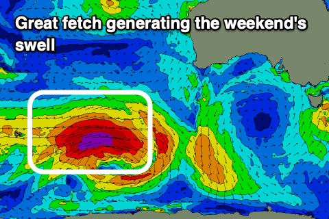
 This trough and another to the west will squeeze a strong high that's moving east, under Tasmania resulting in a strong to gale-force fetch of E/SE winds setting up through Bass Strait this evening (right) and more so tomorrow.
We'll see a rapid increase in E/SE-SE swell through the Strait, kicking tomorrow to 4ft+ across the Surf Coast with 3ft to possibly 4ft sets on the Mornington Peninsula and Phillip Island beaches.
Conditions will be a stormy mess on the Surf Coast with the associated wind, while selected locations to the east may offer some slight protection at times through the day (less likely dawn).
The troughs are due to combine and form into a weak low to our west while drifting south as the high under Tasmania continues to shift to the east. This will see winds shift E/NE through Friday morning, more NE through the afternoon and even possibly N/NW late on the Surf Coast.
The E/SE-SE windswell will drop rapidly though as winds do a similar shift around the compass in Bass Strait, cutting off the swell generating potential. Size wise the Surf Coast looks to ease from 3ft+ early Friday, with 2-3ft sets east of Melbourne, much smaller into the afternoon.
Saturday should offer clean conditions on the Surf Coast with a morning W/NW offshore, but the swell will be tiny.
 We then look at the inconsistent, long-period W/SW groundswell due into Sunday. The low linked to this swell is currently generating a great fetch of severe-gale to storm-force W'ly winds, just east of the Heard Island region. The low will weaken today while dipping east-southeast, leaving a strong, inconsistent and good long-period W/SW groundswell to travel out towards us.
The swell is due to arrive Saturday and will slowly build through the day, likely reaching 2-3ft by dark on the Surf Coast, 4-5ft to the east though with strong SW winds in the wake of the low moving east across us through the day.
Sunday should see infrequent 3-4ft sets on the Surf Coast magnets, 5-6ft to the east if not for the odd rare bigger one at times across both regions, but winds will remain onshore and fresh out of the S/SW tending S/SE in the wake of Saturday's change.
Monday looks better with a dawn E/SE breeze due to swing NE through the morning, then N/NW ahead of another trough and stronger afternoon S/SW change. The groundswell will be on the ease though, dropping from 2-3ft and 4-5ft respectively.
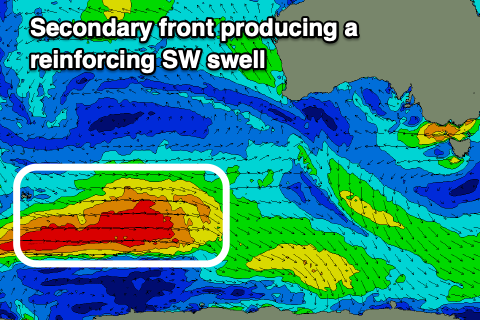 Into the afternoon and more so Tuesday, a reinforcing W/SW swell is due, produced by a secondary polar front firing up on the back of the current low, generating a fetch of W/SW gales in our distant swell window. This front will weaken but maintain a fetch of strong W/SW winds under the country on the weekend, followed by yet another frontal system Sunday.
Fun levels of reinforcing swell are due, with the first peaking Tuesday morning to 3ft+ on the Surf Coast magnets, 4-5ft+ to the east though strong SW winds look to spoil things. Similar sized surf is likely Wednesday though with no letup in the local winds, possibly cleaner Thursday. We'll take a closer look at this on Friday though.
Comments
Is there going to be any SW groundswell hiding in this SE mess Crangle? Asking for a friend.
Tell your friend no.
I think South Channel weathervane’s time is up. At the back beach and it’s looks like tv static with all the whitecaps yet old mate vaney reckons it’s a cool 14 knots. Time to go bro. Off to the glue factory for you.
What a miserable Summer Victoria (Melbourne) brings for 2 years in a row and Im not just relating to surf ESPECIALLY on the WC.
Thank fuk I missed the last one but super depressed I have to stick around for this shite. East coast of Melbs must be better...
Mollymook perhaps?
Not much better to the east, on par with last years shithouse summer (but hey, at least the weathers been cool)
Maybe you're not looking at right spots views. I have had a number of pretty good sessions for this time of year this month. Last weekend was good at many point/ reef and beach breaks all along the G.O.R. 3 days of swell and decent winds at times. There have also been a number of decent (small) days at the more protected points as well this month. Generally crowded, but you have to expect that at this time of year.
Any chance Swellnet could organise a spit and polish (paging Gary G) of the LP cam? Thanking you in advance
First time it's been dirty in about five years.. not worth cleaning until the easterly pattern passes (otherwise, we'll have to send someone down again).
Must be some easterly pattern. It seems these easterly patterns are a more common occurrence. And/or in severity. Maybe the installation of windscreen wiper type system?
Yeah, it's the result of the easterly pattern. They come and go. It's not particularly 'severe' either - onshore winds from any direction will salt up the cameras. Other locations facing south-west - i.e. Woolamai - see the same effects more frequently from south-west wind regimes.
4-6ft of easterly swell is defo on the upper spectrum of an easterly pattern, just can’t see it right now. Short lived and windy unfortunately unlike the last one ;)
How long before the Woolamai Cam gets Fixed? Been a Long Time. The Best Cam in Vic needs to be Here.
Borders are now finally reopen for NSW residents, so I'm scheduling a Vicco mission in the next month or two. We've got a huge backlog of work.
Cheers Ben - looks like majority of Vicco cams are in need of some touch-ups at the moment - Torquay & OG look ok.
Cheers Ben.
Any word on when the Juc cam might be on again?
We don't have a Juc cam.
Yeah every summer has a period of shitty easterly winds which hang around for a few days at least. Once they get in they don't want to piss off in a hurry unlike a SW or W front and yes the front and back beaches are a mess with zero swell.
Bit of action for the right craft here.. through the fuzz..
The right craft being a beach fishing rod
Ha.
Craft beer? It’s Thursday..
Question for Craig/Ben/Weather crew.
Why do Easterly's tend to have such a crazy gradient in Vicco?
The further you go south, the stronger they get.
Seems to not occur with the usual cold front/low pressure systems coming from the West. As in, strong Westerly fronts get 30-40 knots all the way up from say level to Phillip Island to Melbourne, whereas right now it's barely 10knots in the city but howling through South of the heads.
Looks like there are two factors, one being where the strongest of the pressure gradient is (south of or north of the lower pressure) and secondary the funnelling of Bass Strait due to topographical effects.
With the trough to the north, squeezing the high to the south as we're currently seeing, the pressure gradient is strongest south of the trough, ie towards Tasmania. Hence winds are strongest south into Bass Strait.
Winds also appear to be squeezed when from the east, between the mountainous regions of Victoria and the land mass that is Tasmania, hence creating stronger winds. It looks like Melbourne is in the lee/shadow of this and seeing more variable winds and also if right where the trough/low is, there'll also be lighter winds.
When a front comes from the other direction (west), the high is to the north of it, with lower pressure to the south, with the strong pressure gradient setup through Bass Strait and north across Melbourne. You also don't get the blocking of the wind from mountains to the west either.
Cheers Craig - interesting stuff....love the variability of weather down here that's for sure.
Although they don't create good surf....summer easterly's always bring a different feel, you can feel the moisture in the air!