Nothing until late week, strong swell for the weekend

Victorian Surf Forecast by Craig Brokensha (issued Monday 25th)
Best Days: Selected spots Thursday, beaches Friday morning, Sunday for the keen, beaches Monday morning
Features of the Forecast (tl;dr)
- E/SE-SE windswell building Thu with strong E/SE winds, easing Fri with morning E/NE winds
- Inconsistent W/SW groundswell building Sat PM, peaking Sun with light S/SE morning winds, easing Mon with a N/NE offshore
Recap
A great weekend of waves with building surf through Saturday with strong sets across the swell magnets across both regions along with light winds. Yesterday morning was the pick with glassy, clean and lined up S/SW groundswell sets and variable winds.
This morning we've got still got plenty of size on the Surf Coast (more than anticipated) and great conditions again, easing back from 3-4ft, 3-5ft to the east owing to the southerly direction of the swell.
Make the most of the conditions as a shallow S/SW change is due early afternoon.
This week and weekend (Jan 26 - 31)
The current swell will fade more noticeably this afternoon and evening, leaving small surf across both coasts into tomorrow morning. A light, dawn W/SW breeze may be seen but this will strengthen from the S/SW shortly after, and with the swell bottoming out in size and power, it looks like a lay day.
The change will be associated with a strengthening trough come weak low moving in from the west-southwest and with this we'll see a weak increase in S/SW windswell Wednesday though with strong S tending S/SW winds. Size wise the Surf Coast looks to come in around 2ft to possibly 3ft or so, 3ft or so to the east.
This trough/low is then forecast to clear off to the east as a strong high moves in south-west of us, squeezed by a secondary inland surface trough deepening to our north. This will bring strong E/SE winds through Bass Strait from Wednesday evening through Thursday, kicking up a stormy E/SE-SE windswell through the day.
The Surf Coast will likely reach the 4ft range Thursday, with peaky 3ft waves to the east with cross-shore E/SE winds. It won't be great but the beaches just out of the wind a little should be OK.
The trough is forecast to drift south to our west, tipping winds E/NE through the morning as the E/SE-SE windswell eases, backing off from a peaky 2ft to occasionally 3ft on the Mornington Peninsula, bumpy 3ft on the Surf Coast.
 Come Saturday, winds will shift around to the N/NE ahead of an afternoon change but size wise, there'll be nothing major left with small to tiny leftovers across the Surf Coast and Mornington Peninsula.
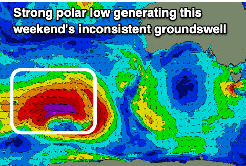
Now, as touched on last week, there's a good, inconsistent W/SW groundswell due on the weekend, generated by a strong polar low that's currently forming north-east of Heard Island.
A pre-frontal fetch of NW gales will be followed by severe-gale to storm-force W/SW winds, projecting east and then weakening south-west of Western Australia Wednesday afternoon.
This should produce a good, inconsistent W/SW groundswell that's due to build Saturday, peaking Sunday. The Surf Coast should reach an inconsistent 3-4ft, with 5-6ft sets to the east, and there might be at times the odd bigger sneaker. Unfortunately winds will shift S/SW Saturday afternoon as the trough from late week pushes east, leaving S/SE winds into Sunday. They don't look too strong so there should still be some OK waves. Monday looks cleaner with a NE offshore but the swell will be easing.
Longer term there's mid-period swell energy due next week but winds look dicey. More on this Wednesday.