Cleaner weekend as the swell fades

Victorian Surf Forecast by Craig Brokensha (issued December 25th)
Best Days: Tomorrow morning on the beaches, possibly Sunday morning exposed breaks for a small, slow wave, Tuesday and Wednesday mornings for keen surfers
Features of the Forecast (tl;dr)
- Easing, weak, SW swell tomorrow with variable morning winds, further Sun with fresh N/NE winds ahead of a strong SW change
- New, localised W/SW swell for early next week with light morning onshore winds
- SE windswell for late week
Recap
Generally poor conditions yesterday with fresh to strong onshore winds and a mix of building mid-period swell and localised windswell.
Today conditions remain very average with fresh onshore winds and 2-3ft sets on the Surf Coast, 4ft to the east.
This weekend and next week (Dec 26 – Jan 1)
Today's swell will ease in size and period through the weekend as winds improve across the beaches though tomorrow morning looks more variable now than true offshore.
So with this expect clean wave faces but not the most perfect conditions. Winds also look to go W/NW-NW late morning east of Melbourne so get a surf in on the beaches before this.
The surf should be easing back from 3ft+ on the exposed beaches with small, fading 2ft sets on the Surf Coast, not ideal on the morning high tide.
Sunday looks clean still with a fresh N/NE offshore but the surf will be small to tiny, with a strong SW change due into the early afternoon.
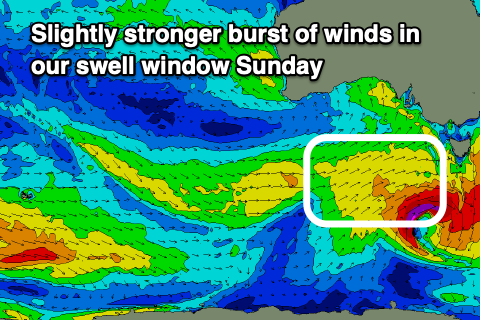 Looking at the swell due in the wake of Sunday's change and there's been a slight upgrade in the strength of the cold front linked to it, with a burst of strong to near gale-force W/SW winds forecast to be generated through our close-range swell window Saturday evening and Sunday, with a much weaker trailing front Monday.
This should produce a slightly better pulse of short-lived W/SW swell, building Monday, reaching 2-3ft on the Surf Coast and 4-5ft to the east, easing from a similar size Tuesday.
The easing trend will be slowed Tuesday by the trailing weaker frontal activity, smaller Wednesday. Conditions still look poor Monday with a fresh S/SW breeze, lighter Tuesday morning and from the SW, creating OK conditions for the keen.
Wednesday looks similar but with light winds from the S/SE creating OK conditions for the keen with easing 2ft+ waves on the Surf Coast, 3-4ft to the east.
Into the end of the week winds will deteriorate and strengthen from the S/SE on Thursday and then E/SE Friday as an inland surface trough deepens north of the state, squeezing a strong high to our south-west. This will spoil an inconsistent, long-period W/SW groundswell due to build Thursday afternoon (though with no major size) while also kicking up a localised SE windswell Friday but with poor conditions. We may see improving conditions on the beaches next weekend, but more on this Monday. Have a great weekend and Merry Christmas!