Make the most of the small, clean waves

Victoria Forecast by Craig Brokensha (issued Friday 10th July)
Best Days: Today, tomorrow, later next week
Recap
A drop in size yesterday across all locations but steadying today with fun 3ft sets on the Mornington Peninsula and 2ft sets on the Surf Coast with favourable winds all day.

This weekend and next week (Jul 11 - 17)
The weekend will see more of the same background swell energy with inconsistent 3ft sets east of Melbourne, 2ft on the magnets across the Surf Coast and winds should be favourable for all regions and locally offshore (N/NW Surf Coast and N/NE-N Mornington Peninsula) ahead of weak afternoon sea breezes.
Sunday looks average with a dawn W'ly expected to give into a SE change mid-morning or so and with the small swell it's a lay day as conditions deteriorate.
Into early next week we'll see conditions deteriorate further as a strong low pressure system develops off the southern NSW coast, squeezing a strong high sitting south of Tasmania, directing strong E/SE winds through Bass Strait. This will kick up a poor quality SE windswell for both coasts but with strong SE winds on Monday, persisting into Tuesday as the low remains slow moving.
Unfortunately Wednesday will remain poor with winds lingering out of the SE, though likely starting to swing E/SE as the low starts to broaden and move east across the Tasman Sea. This will spoil a mix of new long-range W/SW groundswells, with even Thursday now looking a little dicey.
An initial in very inconsistent long-period energy for later Tuesday, peaking Wednesday has been generated by a strong frontal progression that developed south-east of South Africa and projected east through the southern Indian Ocean.
No major size was expected with very infrequent 1-2ft sets on the Surf Coast (and the local SE windswell will be bigger), possibly 3-4ft to the east.
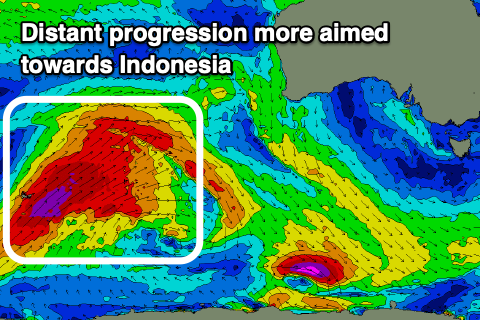 The secondary slightly more consistent and better W/SW groundswell for Thursday now looks a little less so, arriving later in the afternoon now and peaking Friday. The intense storm linked to it, developing east of Heard Island, is now expected to project up towards Indonesia rather than more east through our swell window.
We'll then see inconsistent and small surf building Thursday and likely peaking Friday morning with sets to 2-3ft on the Surf Coast magnets, 4-5ft+ to the east. Winds should swing around to the N/NE by Friday, though we'll have to review this on Monday owing to the dynamic nature of the low in the Tasman Sea.
Longer term another long-range and inconsistent W/SW groundswell is due next weekend with winds out of the north-northwestern quadrant, but more on this next week. Have a great weekend!
Comments
Phillip Island looking nice this arvo.

Yer