Poor surf continues, with one OK window

Victoria Forecast by Craig Brokensha (issued Wednesday 12th February)
Best Days: Exposed beaches Friday
Recap
Clean conditions across the Surf Coast yesterday morning and even OK to the east with a small mix of inconsistent W/SW groundswell and fading SE windswell, 1-2ft on the Surf Coast and 2-3ft to the east.
Today conditions are poor across all coasts with onshore winds and a small, weak windswell.
This week and next (Feb 13 – 21)
More poor surf will be seen tomorrow with no new groundswell and moderate to fresh E/SE tending stronger SE winds, kicking up a building SE windswell across most locations through the day.
Our window of cleaner conditions on Friday is still on track with a light morning E/NE-NE breeze due across most locations, possibly variable on the Surf Coast along with a mix of easing SE windswell and background long-period groundswell on the Mornington Peninsula.
Size wise, easing SE windswell waves are due to 1-2ft on the Surf Coast with the groundswell coming in around a similar size, with the Mornington Peninsula offering very infrequent 3-4ft sets. Be patient and you should have fun. We still may see winds hold out of the E/NE most of the day, otherwise S'ly sea breezes will kick in. The models still diverge on this unfortunately.
There's been no improvement to the weekend outlook with a surface trough moving in from the west Friday evening due to bring fresh to strong onshore S/SW winds along with the easing groundswell from Friday. A weak windswell will build and then winds are due to do an 180 switch and blow E/SE into Sunday.
 The timing of this switch is still up for grabs with EC showing it occurring at dawn Sunday, while GFS has it into the late afternoon and evening. Either way the surf will remain very poor.
The E/SE winds will continue into Monday kicking up some new SE windswell for the Surf Coast, easing Tuesday as winds relax but winds remain onshore out of the SE.
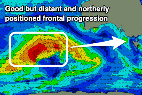
Our new W/SW groundswell for Wednesday is still on track, with a strong frontal progression forecast to develop around the Heard Island region, projecting a fetch of W/SW gales up towards Western Australia, weakening directly south-west of the state.
This will result in a loss in size and consistency, but the swell should offer some fun sized sets across the exposed beaches, building Wednesday and reaching 4-5ft+, smaller and to 2-3ft on the Surf Coast. The only issue are the local winds, as per usual and they look SE for the most part, possibly weaker through the morning and then likely more favourable Thursday as the swell eases, but we'll have a closer look at this on Friday.
Comments
Three devil weeks and counting.
Aside from the odd day here and there, it has been a very lean spring and summer for both coasts.
Huh, spring was great? Lots of clean Surf Coast days with fun sized swells? Remember from the SSW event and then negative SAM events.
Yep, decent reef waves right into January 2020 but this little stretch is starting to get a little old. Any scalpers out there that wanna sell me an Urban Surf advanced session on either the right or left during this forecasted dismal period?
Good point Craig. My memory is clouded by the recent bad run. That said, it pumped the Aus Day long weekend through to the Tues. That was sick.
There is a lot more to Victoria than the Surf Coast. For anywhere west and east of it has had one of the worst spring/summer's in recent memory
Yup, it has been truly wretched to the east.
Yes, this present shite surf period is rubbish. I will give Gunnamatta a go on Friday but overall I am sick of reading about shite surf conditions and hope for a day or two of offshore winds and SW groundswell.
I do appreciate being able to read the forecaster notes, but recently it's been like self-flagellation.
Reckon Friday's gonna look like the food drops over occupied Berlin.
Serious question.......
When it's pumping down here it's generally shithouse conditions on the East coast of Aus.
Whereas when they get a good run (like now) you can almost bet on it being putrid here.
Maybe I've got selective memory but I can't remember both those parts of Aus being good at the same time for any length of time.
Why is it so?
Yep, usually the case, but not always.
It's because the synoptic pattern for say the Goldy to light up, ie strong high across the Tasman Sea or say south-east trade setup means the high is sitting across you guys, directing east-southeast winds across the region, plus setting up a blocking pattern in the Southern Ocean.
But when cold fronts are pushing up and across Vicco they're producing west to south-westerly winds across the East Coast but with no swell.
It's why during winter chasing snow from those fronts and forgetting the surf are mutually exclusive, ie not missing out on waves for POW.
Thanks Craigos. Makes sense for sure. It also seems like when those southern ocean lows intensify S/W of us and provide good groundswell then they drift across to the Tasman and weaken with nothing left for much N of the South coast.
Then fir some reason we get an Anzac or Easter long weekend and the whole country pumps
Here's my forecast notes.
Move to the east coast. If I'm not mistaken it's back to back cyclones for the East Coast.
It' shit in Victorian for as far as the eye can see.
Yep rubbish however I wonder if the small continuous E-SE winds will move around the sand on the beachies east of PP and push it into the western corners like the southerlies did on the east coast. When this extraordinarily putrid run ends could be so fine waves around.