A couple of fun days for the beaches, large into the weekend

Victoria Forecast by Craig Brokensha (issued Monday 16th December)
Best Days: Exposed beaches tomorrow morning and Friday, protected spots Sunday through Monday
Recap
Small waves around the 2ft range on the sets across the Surf Coast magnets all weekend, clean in the mornings and bumpy into the afternoon.
A new inconsistent W/SW groundswell due today is just that, with long waits for the sets but up to 3ft on the Surf Coast swell magnets (below) and 4ft+ to the east. Light and variable winds have favoured the Surf Coast over the beaches to the east and sea breezes will pop up through the day.


This week and weekend (Dec 17 - 22)
The inconsistent groundswell seen later yesterday and this morning has peaked and it'll be a slow downwards trend from here, into tomorrow, bottoming out Wednesday.
The models were a little divergent surrounding the winds for tomorrow morning, but we've now got verification of a light NE offshore, favouring the exposed beaches with easing sets from just over 3ft (inconsistent) and 2ft max on the sets on the Surf Coast ahead of S/SE sea breezes.
Wednesday morning will be clean again with a light NE offshore but the waves tiny on the Surf Coast and dropping from an inconsistent 2ft on the Mornington Peninsula.
As talked about last update, some very inconsistent W/SW swell is due into Thursday and Friday across the state.
These were generated by back to back mid-latitude fronts developing west-southwest of WA on the weekend, with the progression now tracking east-southeast through our south-western swell window.
This movement isn't ideal at all and the fronts are relatively weak, producing some small reinforcing SW swell for later in the week, that being mostly Friday.
Size wise, the Surf Coast is only due to be small to tiny with the first pulse of W/SW and SW swell Thursday, coming it at 1-2ft on the swell magnets, with the Mornington Peninsula offering inconsistent 2-3ft sets.
Friday looks to offer a touch more consistent size, but again only hanging around 2ft on the Surf Coast and 3ft+ on the sets to the east.
 Winds on Thursday will be poor as a surface trough moves in from the west, bringing onshore S/SW winds, shifting S'ly into the evening, while Friday looks fun as winds shift back to the N/NE an likely hold into the afternoon and evening as another trough approaches from the west.
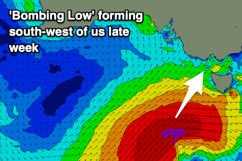
Looking to our south-west, a significant storm is forecast to develop in the Southern Ocean, in fact it'll be a 'bombing low' with a couple of low pressure centres west-southwest of WA expected to track south-east, with one of them dropping over 24hPa in central pressure in less than 24 hours.
The low will drop to 961hPa south-southwest of Tassie, with a fetch of severe-gale to storm-force S/SW winds forming on its backside, moving slowly east through our southern swell window Friday and Saturday. The movement will be that slow that it'll only leave our swell window come Sunday afternoon.
A large, long-period SW tending S/SW groundswell is due Sunday, easing slowly while swinging more south in direction and easing through Monday and Tuesday.
The Surf Coast should see large sets to 6-8ft on the swell magnets, 8ft+ to the east but onshore SW tending S'ly winds will leave no real quality surfing options.
Monday will remain onshore but with less strength, opening up a few breaks with the swell large and easing from 5-6ft and 6-8ft respectively. Tuesday looks average as winds become a little fresher from the S/SE but more on this Wednesday and any changes to the expected size and winds.
Comments
Well, that is a surprise.
SSW related?
Nice waves today despite slight onshore, size as forecast.
Not sure where it's coming from this time.. And good to hear!
Ooooeeee. Gotta set me up a food stall. A lot of hungry customers gonna be at the circus.
So ya get ya offshore winds and now complain about the people ;p
Ey ey ey. Not complaining about the crowds with the offshores, I’ll probably be continuing my non-surfing due to busy last week at work. Was just saying in a round about way that there be a lot stars aligning for a shit show at the circus down the road haha.
Small NE isn’t my bread and butter in the slightest anyways. Gimme my 4-6ft gentle SE after a morning offshore any day of the week.
Small offshores perhaps when im not working to be utilised elsewhere.
Highlight was watching young one getting pitched with a grab rail takeoff into a tube this morning, pretty awesome view
Speaking of circus, I'd estimate 60 out across the most famous two named waves, we went elsewhere, with the inconsistency that would make for a fair bit of sitting, floating
And two weeks ago when it was pumping, there were only handfuls out through the day!
How south is that swell on Sunday as it opens a few more options?
Hey Craig I’m leaving to Tassie on the spirit Saturday night. Rough crossing ahead?
Hey mate, actually not too bad, locally winds aren't anything to worry about, you'll be able to feel the roll of the swell though.
Awesome, kids can sleep while I drink! Merry Christmas and thanks for all your great work this year!
Thanks and to you too!
Thanks Craig & Ben for the forecasts, it's nice to be able to read them again.
https://www.willyweather.com.au/news/11191/temperature+record+could+be+r...
Decent heatwave approaching! On the coast it's forecast lower at 19 on Thursday, but inland BOM are seeing high 40's, maybe even as high as 48! Stay safe everyone.
Sunday still looking around the same size?
Latest FC..
https://www.swellnet.com/reports/forecaster-notes/victoria/2019/12/18/day-the-beaches-followed-large-powerful-swell