Windy sizey week, unclear weekend

Victoria Forecast by Craig Brokensha (issued Monday 19th August)
Best Days: Surf Coast tomorrow and early Wednesday, Surf Coast Friday and Monday
Recap
Small and inconsistent surf all weekend, a bit morning sick and not great Saturday with variable winds, cleaner yesterday but on the small to tiny side.
Today our new mix of swells have filled in, with good 3-5ft waves already reported on the Surf Coast this morning in protected spots, choppy and to 6ft+ to the east.
Today’s Forecaster Notes are brought to you by Rip Curl
This week and weekend (Aug 20 - 25)
We should see today's mix of building long-period SW groundswell and mid-period swell peaking this afternoon (4-5ft+ Surf Coast and 6-8ft to the east) dropping back slowly through tomorrow, but a weak cold front moving up and into us through this afternoon and tomorrow will strengthen. A fetch of strong tending gale-force W'ly winds will be projected up and towards us, with an embedded low now forecast to generate stronger severe-gale W/SW winds in our south-western swell window later tomorrow.
The size is expected to steady through tomorrow and hold at 3-5ft on the Surf Coast and 6ft to possibly 8ft on the exposed beaches to the east along with gusty W/NW winds, keeping protected spots clean all day.
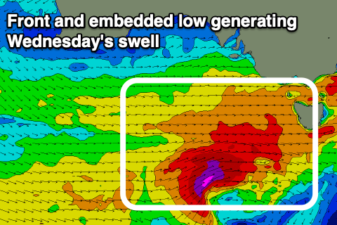 The developments surrounding the embedded low, will see a larger SW groundswell filling in Wednesday, building to 4-6ft across the Surf Coast into the afternoon and consistent 6-8ft range on the Mornington Peninsula but with fresh to strong W/SW winds (W/NW early around Torquay).
On Friday I pointed out that the models were incorrectly combining swells and over-forecasting the size late week, but with the developments of the stronger embedded low it is lining up a little better for Wednesday through Friday, though still over-forecasting the size a little.
The surf should drop through Thursday with fresh but easing SW winds, with the chance of an early W'ly around Torquay low.
Easing surf from 4-5ft is due on the Surf Coast Thursday morning and 6ft to possibly 8ft on the Mornington Peninsula. Friday looks much cleaner with a NW breeze as the surf continues to drop in size from 3ft to maybe 4ft on the Surf Coast and 5-6ft to the east.
The downtrend in size will continue Saturday morning but it won't last long, with a new SW groundswell possible Sunday. The models diverge around a strong polar storm forming south-west of WA later week, projecting north-east up and into us, with EC having a totally different scenario and weaker trough-come possible low developing on the weekend.
With the strong divergence we'll have to review Sunday and Monday's swell prospects on Wednesday and Friday.