Another flukey swell tomorrow, then more reliable energy from late week

Victoria Forecast by Craig Brokensha (issued Monday 10th June)
Best Days: Exposed beaches tomorrow afternoon, Surf Coast Thursday through Sunday, best Friday
Recap
Saturday's secondary pulse of tricky S/SW groundswell came in better than expected which is always a plus, with 3ft waves on the Surf Coast and 4ft sets on the Mornington Peninsula under favourable local offshore winds.
The swell dropped back into yesterday to a smaller 2ft on the sets across the Surf Coast and 2-3ft on the Mornington Peninsula with less favourable winds.
A slight kick in new swell should have been seen into the late afternoon, though fading this morning from a small to tiny 1-2ft across most breaks.
Today’s Forecaster Notes are brought to you by Rip Curl
This week and weekend (Jun 11 - 16)
As touched on in Friday's update, a pulse of W'ly swell showing on the charts this afternoon and evening has no size to it, with it being W/NW in direction, generated by a cold front moving across us, generating a fetch of strong W/NW winds.
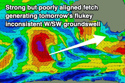 Tomorrow will see a tricky, new and inconsistent W/SW groundswell filling in though, produced by the earlier stages of this front as it pushed up from south-west of WA, at a poor angle through our swell window.
An impressive fetch of gale to severe-gale S/SW winds were generated perpendicular to our swell window, with some small and inconsistent W/SW groundswell spreading off radially towards us.
The swell should fill in through the morning and peak through the middle of the day/afternoon to an infrequent 2ft on the Surf Coast swell magnets, tiny elsewhere, with 3to hopefully 4ft sets on the Mornington Peninsula.
Winds will become more favourable through the day for exposed beaches with a dawn and average NW breeze due to swing more N/NE later morning and into the afternoon.
 Wednesday will see the swell fading from 1ft to maybe 2ft on the Surf Coast and possibly 3ft on the Mornington Peninsula with a small window of clean conditions across exposed breaks. A dawn and fresh N'ly will quickly shift N/NW mid-morning and then W/NW through the afternoon with an approaching front.
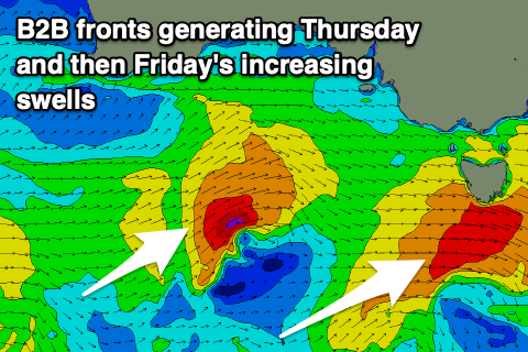
This front won't have too much strength, with a quick burst of strong W/SW winds being projected through our western swell window, while a secondary small low moving in quickly behind it will project a better fetch of strong to gale-force W/SW winds directly through our western swell window towards us.
A mid-period increase in W/SW swell is expected from the first front Thursday, building to 3ft on the Surf Coast swell magnets and 4-6ft on the Mornington Peninsula under a fresh NW tending W/NW breeze.
Friday looks better with a stronger groundswell and more size to 3-5ft on the Surf Coast and 6ft+ to the east as winds persist from the NW, possibly tending lighter N/NW into the afternoon.
Moving into the weekend, Friday's W/SW swell will ease as NW winds continue to favour the Surf Coast, with smaller background groundswell pulses not letting the Surf Coast drop below 2-3ft across magnets into Sunday and 4-5ft on the Mornington Peninsula. Sunday will see a morning NW breeze ahead of a shallow SW change as a weak trough moves through.
Longer term broader and stronger polar storms developing south-west of WA and moving slowly under the country on the weekend look to generate better pulses of W/SW and SW groundswell into the middle of next week, but... we may see a trough moving in from the west deepening into a low, bringing poor onshore S'ly winds. More on this Wednesday though.