Change to the incoming large swell, but slightly for the better

Victoria Forecast by Craig Brokensha (issued Monday 27th May)
Best Days: Surf Coast tomorrow and Wednesday, possibly early Friday and Saturday mornings Surf Coast for keen surfers
Recap
Great waves all weekend on the Surf Coast with offshore winds and 3-4ft of SW swell Saturday, out of the W/SW on Sunday. Selected locations to the east were good, but not great.
This morning a new close-range W/SW swell from a strong frontal system pushing into us yesterday and this morning has boosted wave heights to 4-5ft on the Surf Coast and 6ft+ on the Mornington Peninsula and with better than expected conditions on the Surf Coast owing to the change to the incoming activity. Winds will shift W/SW into this afternoon as the swell steadies.
Today’s Forecaster Notes are brought to you by Rip Curl
This week and weekend (May 28 – Jun 2)
The structure of the strong and vigorous polar frontal progression forming today to our south-west has changed since Friday. We've got a downgrade in the expected size, but along with this more favourable winds into Wednesday for a longer period before the onshores kick in.
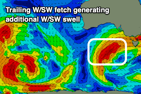
 The main structural change to the progression is that we'll see a broad and more northerly positioned low with multiple fronts spawning on its western flank, pushing up initially in our south-western swell window and then western swell window.
Today's swell will drop into tomorrow morning ahead of a building mid-period mix of W/SW and SW swell, followed by groundswell on Wednesday.
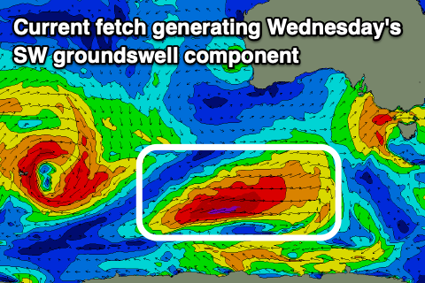
Currently, south of WA a strong polar front has formed, with a fetch of severe-gale to near storm-force W/SW winds aimed through our south-western swell window. We'll see this frontal system weaken slightly but project up slowly towards us this afternoon and evening, aiming strong W/SW-SW winds in our swell window.
On the tail of this front though we'll see stronger W/SW gales aimed through our western swell window all of tomorrow, weakening as the system moves in across the state on Wednesday.
A large SW groundswell will be produced by the initial polar fetch, arriving Wednesday afternoon, mixed with a W/SW groundswell from the tail fetch but ahead of this mid-period energy will build tomorrow. The Surf Coast will likely build from 3-5ft in the morning and 6ft+ to the east, to a slightly larger 4-6ft on dark and 6-8ft to the east along with persistent and fresh NW tending stronger W/NW winds.
 The groundswell will be bigger and stronger, building through Wednesday and reaching 6ft+ on the Surf Coast and 8ft to maybe 10ft on the Mornington Peninsula. Winds now look to hold strong out of the W/NW most of Wednesday, shifting W/SW mid-afternoon and into the evening.
The end of the week and into the weekend then looks poor with the progression continuing slowly east, directing onshore SW-S/SW winds across the state Thursday as the swell eases from a large 5-6ft and 6-8ft respectively, smaller Friday (easing from 3ft+ on the Surf Coast) and back to mid-period energy with SW winds. There's a slim chance for an early W'ly on Friday morning though not worth the drive from Melbourne.
The models diverge a little on the winds and weather for the weekend, but in general onshore SW breezes look to persist on the Mornington Peninsula Saturday morning, possibly W'ly early on the Surf Coast but small and weak, cleaner Sunday with a N/NW offshore though easing 2ft sets on the Surf Coast and 3ft to maybe 4ft sets to the east.
Longer term there's nothing significant on the cards until later next week as strong and slow moving blocking high dominates our swell window from the weekend into early next week. More on this Wednesday though.
Comments
In the bottom pic, are those two red patchs nodes of the/a (?) LWT? If so, will that mean that in between will always be a blocking pattern/high?
No, but they are storms that have developed and tracked to where they are under the influence of the Long Wave Trough.
Here's the current LWT setup..
There are two strong nodes and yes in between then an upper level ridge or block. This block will always be there between two strong nodes, but if the nodes are moving quickly from west to east then it won't be stationary enough to block swell.
But if the nodes are slow moving, as they are now, then the block will affect us.
How slow moving Craig? I have completely mistimed the LWT this year and am scraping small rides out of a lake. Does the LWT pass on from Vic after the weekend? If so, D'oh!
(That said, I had the opposite to the discussion on the forecast notes yesterday - just a couple of us in little beachbreaks on logs, even a little shape. No worry of crowds, who is a local, who isn't, how to respect your fellow people, which people are evil by their ancestry, etc. Just us taking turns. All equal in the sea.) But yeah, next year I'll be booking flights only after the LWT is consulted...
Fairly slow moving, ie in a week it only travels this far (weakening from the Indian Ocean though maintaining strength across NZ after moving from south-east of Australia)..
The 2nd chart - D'oh!
At this rate I'll become an alright goofy foot...
The reason for all the snow that's to come this week is due to the slow moving nature of the LWT over the south-east of the country. It's directing back to back cold fronts up into the country and mountains.
Get that split board ready
Plans already made! Can't wait.
I think I'm gonna have to book a trip to the mountains in late June as it looks like there is going to be some nice snow for the early season! I almost froth on snowboarding more than surfing these days.
get on the skis mate...you will realise how crap snowboarding feels under the feet....trust me skis just work better feel better and are more fun. anyway hopefully this snow doesnt melt away and creates a good base for vic.
Possibly but I want to keep my knee joints in tact ;p
Dunno if its a simple question or not, but what determines the speed of the LWT?
Generally the more nodes around the hemisphere the faster it moves, and the less nodes, the slower. The number of nodes can vary from three to about seven.
Hey Craig. Is that swell for Wednesday just coming at a different angle? Would it still be expected to be real big further west? Will the swell be more southerly there??
Yes still real big but more west in direction.
Thanks. Would you expect it to be more southerly in direction in western Victoria? And arriving earlier? I live in Warrnambool.
I'd go south-west.. if not a touch more west of south-west than true south-west.
then it doesn't matter, its only a short(ish) drive
Probably enough said.
:(
Big difference between Torquay area and further down Ocean road. The westerly aspect had us 1-2 feet under the surf report. 4-5 ft there and we were looking st 3 ft . Instead of a 7 out of 10, a 4 or 5 tops it of 10. Same angle but the westerly swells give us shit
How do you think the next two days will play out?
This is generally the case under any swell from the W/SW-SW, more so the more west. S/SW swells will get in similar across most spots.