Developing onshore winds, improving later week

Victoria Forecast by Craig Brokensha (issued Monday 8th October)
Best Days: Friday both coasts, Saturday morning swell magnets
Recap
Workable waves across both coasts on Saturday with a variable tending light offshore breeze and 3ft to occasionally 4ft sets on the Surf Coast, 3-5ft to the east.
Sunday was great as well with the swell only easing a touch and coming in cleaner and straighter with a light offshore N'ly breeze. A new swell kicked into the afternoon though and this has eased back from 3ft on the sets across the Surf Coast this morning, 3-5ft to the east again.
Make the most of it as we've got a few days of poor conditions ahead.
Today’s Forecaster Notes are brought to you by Rip Curl
This week and weekend (Oct 9 - 14)
The coming forecast period isn't too flash as a strong high moves in from the west and stalls south-west of us, blocking our major swell windows and initially bringing strong E/SE winds and a junky SE windswell which will then fade as winds swing back offshore from the north-eastern quadrant.
The main issue is the blocking nature of the high, preventing any majors swells being generated when winds improve, but there is on of note (more on this later).
But back to tomorrow, and we'll see our current swell easing further, dropping from the 2ft range on the Surf Coast and 3ft+ to the east with early variable winds (possibly SE onshore on the Mornington Peninsula), tending SE across all locations through the morning and then strengthening as the ridge moves in.
Wednesday will then see strong E/SE winds and building levels of SE windswell to 3ft+ or so on the Surf Coast, smaller on the Mornington Peninsula and to 2-3ft.
Winds will start swinging more E'ly on Thursday resulting in the SE windswell easing, while a small mid-period S/SW swell is due to be in the mix, generated by a weak S/SW fetch on the south-east flank of the high as it moves in.
 The Surf Coast will remain poor with easing 2ft to possibly 3ft peaks, a bit better on the Mornington Peninsula with 3ft+ sets, easing through the day.
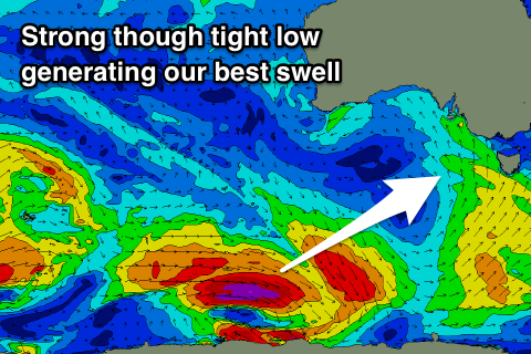
Into Friday winds will continue swinging around, tending NE and possibly even N/NE through the morning along with the arrival of a new long-period SW groundswell.
This will be generated by a strong but distant and small polar low firing up south-west of WA, with a tight fetch of severe-gale to storm-force W/NW winds produced through our south-western swell window.
The swell will be fairly inconsistent but long-period and arrive through Friday morning, building to a peak through the afternoon to 3ft+ on the Surf Coast and 4-6ft on the Mornington Peninsula. Winds will tend variable ahead of mid-afternoon sea breezes, so there'll be a period with a good increase in size before conditions deteriorate.
Moving into the weekend the swell will ease fairly quickly under a N/NE offshore and 2ft to maybe 3ft on the Surf Coast and 4ft to the east, clean but tiny Sunday.
Longer term there's nothing significant on the cards until mid-late next week when we'll likely see a strong mid-latitude frontal progression pushing up towards WA, generating W/SW groundswells with favourable winds across our state. More on this Wednesday.