One decent day this week, lots of activity into next week

Victoria Forecast by Craig Brokensha (issued Monday 24th September)
Best Days: Beaches Wednesday, and dawn Thursday, Surf Coast early Saturday and Sunday onwards
Recap
Pumping waves on the Surf Coast Saturday morning with Friday's large kick in strong and powerful S/SW groundswell coming in over forecast expectations and remaining so into the weekend with easing 3-5ft waves.
Locations to the east pumped as well with early N'ly breezes and large clean sets.
Sunday was poor as an onshore change moved through with the swell halving in size, and today we've got some new SW swell but with persistent onshore breezes.
Today’s Forecaster Notes are brought to you by Rip Curl
This week and weekend (Sep 25 - 30)
Our current SW swell will start to ease through tomorrow and conditions will remain poor but improve through the day with a moderate to fresh S/SE breeze through the morning due to ease into the afternoon.
The Surf Coast should ease back from 3ft+, with 4-5ft+ waves to the east, smaller into the afternoon.
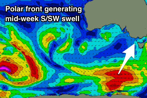
Our new S/SW groundswell and better winds for Wednesday are still on track, generated by a strong polar frontal system swinging in from the south-east Indian Ocean and along the polar shelf. A fetch of W/NW tending W'ly gales were produced in our southern swell window, with the storm currently south-west of Tassie.
 A moderate sized S/SW groundswell is expected, arriving overnight tomorrow and peaking Wednesday morning to mostly 3ft on the Surf Coast and 4ft to possibly 5ft to the east. There may be the odd bigger one on the Surf Coast magnets to keep an eye out for.
Winds will swing N/NE through the morning, favouring the beaches across the state, with variable breezes likely into the afternoon as the swell eases.
Thursday will become small as the S/SW swell fades under an early N'ly tending NW and then W/NW breeze, though only easing from 2ft on the Surf Coast and the 3ft range to the east.
The swell is expected to bottom out Friday morning ahead of a new mid-period W/SW swell building later in the day and peaking Saturday.
This will be produced by a relatively weak though broad frontal system moving in from the west mid-week, with a fetch of strong W/SW winds being projected towards us.
Without wind speeds reaching the gale-force range only a weak mid-period W/SW swell is due, peaking Saturday to 2-3ft on the Surf Coast and 3-5ft to the east.
Winds look average though and generally onshore from the W/SW, with a possible short period of early W/NW winds around Torquay.
From Sunday and more so next week we're due to see much stronger and larger levels of groundswell filling in across the state as a broad and elongated polar frontal progression fires up through the Southern Ocean.
Fetches of W/NW-W/SW gales should produce moderate sized pulses of SW groundswell with a possible larger swell on the cards for later next week, but more on this Wednesday.