Good windows for the Surf Coast

Victoria Forecast by Craig Brokensha (issued Friday 8th September)
Best Days: Surf Coast Saturday morning, Surf Coast Sunday, exposed beaches early Monday, Surf Coast Tuesday and Wednesday morning
Recap
Great waves across the Surf Coast reefs most of yesterday with a slow drop in S/SW energy from the 3-5ft range, while all other locations weren't too flash with the westerly winds.
Today a new close-range SW swell has filled in, generated by a polar front pushing up and into us last night, but conditions weren't as perfect across the Surf Coast with W'ly breezes, though the reefs are still clean. The swell should persist all day but a W/SW change is due around midday.
This weekend and next week (Sep 9 - 15)
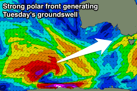
Today's close-range SW swell was generated by a strong polar front projecting up off a polar low that formed mid-week.
The close-range energy should ease through tomorrow (though a small front linked to today's change will slow this trend), but the less consistent and stronger SW groundswell energy will fill in, keeping wave heights up through the morning. The Surf Coast should see inconsistent but good 3-4ft+ sets through the morning with 5-6ft+ waves on the Mornington Peninsula, easing into the afternoon and down further from 3ft and 4-5ft respectively Sunday.
 Conditions won't be perfect but fun tomorrow morning with an early W/NW breeze around Torquay, tending W/SW-SW mid-late morning. Sunday looks great with a NW tending variable breeze.
The surf is due to bottom out Monday morning and there should be a window of clean conditions on the Mornington Peninsula with a fresh N'ly breeze, tending more NW into the afternoon. Sets should be in the 3ft range on the Mornington Peninsula, small to tiny on the Surf Coast, but some new W/SW swell is due to build through the day.
This swell is being generated by a pre-frontal fetch of strong NW winds, south-west of WA with small 2ft sets due to develop on the Surf Coast into the afternoon, with 4ft sets on the Mornington Peninsula.
Of greater significance is the SW groundswell behind it, generated by a strong polar low. A broad fetch of gale to severe-gale W/SW winds will be produced, weakening slowly as the system moves east towards us.
We should see a moderate sized SW groundswell produced, filling in overnight Monday and peaking Tuesday to a strong 3-4ft on the Surf Coast and 6ft on the sets across the Mornington Peninsula with W/NW winds.
This swell will drop through Wednesday with NW offshores ahead of a strong SW change, linked to a mid-latitude front pushing in from the west.
This mid-latitude front will produce a great fetch of gale to severe-gale W/SW winds through our western swell window Sunday and Monday while tracking towards us.
A good W/SW groundswell is due, filling in Thursday and coming in around 4ft on the Surf Coast and 6ft+ on the Mornington Peninsula but winds look onshore at this stage. More on this Monday though. Have a great weekend!
Comments
Coupla small clean waves on the open beaches.