A couple of fun days for the Surf Coast

Victoria Forecast by Craig Brokensha (issued Wednesday 5th July)
Best Days: Surf Coast Thursday, east of Melbourne early Friday, Surf Coast Sunday and Monday
Recap
With the W/SW groundswell due into Monday underperforming there wasn't much left across the coast into yesterday with small clean 2ft waves on the Surf Coast and 3-5ft sets on the Mornington Peninsula with a morning offshore.
Today the swell is around the same size but conditions are best on the Surf Coast with a NW-W/NW breeze. The long-period forerunners linked to an inconsistent new SW groundswell due later today are showing on the Point Nepean and Cape Sorell wave buoys and we should see the swell build later today as winds swing more west.
This week and weekend (Jul 6 - 9)
This afternoon's inconsistent and long-range SW groundswell should peak tomorrow morning to an infrequent 3ft+ on the Surf Coast (4ft sets at Bells and Winki) and 5-6ft on the Mornington Peninsula.
A drop in size is due into the afternoon, further down into Friday from 2ft+ and the 4ft range respectively.
Conditions will be best on the Surf Coast tomorrow but improving late east of Melbourne with a NW tending variable wind (N east of Melbourne near dark).
 Friday will then see moderate to fresh N/NE tending NW winds east of Melbourne and N/NW tending NW winds across the Surf Coast.
As talked about on Monday, a couple of small W/SW groundswells are due over the weekend, with Saturday's looking very marginal, followed by a much better swell Sunday.
Saturday's has been generated by a relatively weak polar front pushing up into WA, unfavourably through our swell window.
The Surf Coast isn't due to see any size with tiny 1-1.5ft waves at swell magnets, while the Mornington Peninsula should offer inconsistent 3ft+ sets. Winds will be average and not too favourable for exposed spots with a fresh NW tending N/NW breeze.
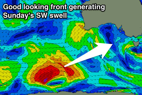
Sunday's better swell will be generated by a stronger polar frontal system that's currently east of Heard Island. A pre-frontal fetch of W/NW gales have produced a small active sea state for a better aligned and stronger fetch of W/SW gales to move over, projecting east-northeast towards us before weakening south of WA tomorrow afternoon.
The swell will be a little inconsistent but should come in at a fun 3ft+ on the Surf Coast (4ft sets at Bells and Winki) and the 6ft range on the Mornington Peninsula with W/NW winds persisting all day as a weakening front passes across us, followed closely by a secondary stronger system approaching from the west.
This front is almost there in regards to strength and positioning but also a little patchy and not totally consolidated. With this we'll have to review the sizes expected Monday/Tuesday but we're likely to see 3ft+ of swell on the Surf Coast and 6ft waves on the Mornington Peninsula with less than ideal winds. More on this Friday.