Good waves continue on the Surf Coast, with windows to the east

Victoria Forecast by Craig Brokensha (issued Monday 26th June)
Best Days: Both coasts Tuesday, Surf Coast Wednesday and Thursday morning, both coasts Saturday
Recap
 Well what a swell event! Into Friday afternoon the Cape Sorell wave buoy stared rocketing and sets pushed 6ft on dark across the Surf Coast with offshore winds.
The 7m @ 18s peak in size seen overnight Friday resulted in monster waves across the Victorian coast with 8-10ft surf at Bells and Winki with larger 12ft bombs. Conditions were raw but surfable with a light W/NW breeze persisting most of the day.
Sunday was pumping with the swell dropping by half but groomed by fresh offshore winds. Easing surf from 4-5ft was seen on the Surf Coast, larger to the east.
Today a new SW swell has filled in, produced by a broad polar front projecting towards us over the weekend. It's not as pumping as yesterday though, with the Surf Coast reefs fairing best.
This week (June 27 – 30)
Today's swell was generated by a broad but not overly strong polar front projecting up towards us through yesterday. This swell will be reinforced by a secondary mid-period SW pulse tomorrow, generated by a trailing fetch of W/SW winds moving through our swell window last night and early this morning.
We should see the Surf Coast hanging in at 3-5ft with 6ft+ sets on the Mornington Peninsula, easing later in the day, down further from 3ft+ and 4-5ft respectively Wednesday.
 Conditions will be great across most locations tomorrow with a N/NW offshore on the Surf Coast and N/NE tending N'ly to the east. Wednesday will be best on the Surf Coast with a fresh NW tending W/NW breeze.
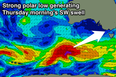
A new moderate sized SW groundswell may be seen late in the day Wednesday, but is due more so Thursday, produced by a strong polar low firing up south of WA today. A fetch of severe-gale W/SW winds will be projected nicely through our south-western swell window, with the system weakening while approaching us tomorrow.
The swell should peak Thursday morning to 3-5ft on the Surf Coast again with 6ft+ sets to the east and pre-frontal W/NW winds will create clean conditions ahead of a gusty W/SW change through the afternoon.
This change will be linked to a secondary polar front pushing up and into us, generating a messier SW swell for Friday. We're probably looking at messy 4-5ft surf to the west of Melbourne with 6-8ft waves to the east along with fresh but easing SW winds (likely W'ly early around Torquay).
This weekend onwards (Jul 1 onwards)
Friday's swell is due to ease into Saturday as winds swing back to the N'th ahead of a vigorous mid-latitude frontal progression moving through the Bight.
This progression is due to generate a moderate to large W/SW groundswell for later Sunday/Monday with N/NW breezes, but more on this Wednesday.