Large dangerous swell Saturday, pumping Sunday

Victoria Forecast by Craig Brokensha (issued Friday 23rd June)
Best Days: Experienced surfers Surf Coast Saturday, Surf Coast Sunday, Surf Coast early Monday, Tuesday and Wednesday
Recap
Great waves across the Surf Coast all day yesterday in the 4ft range (bigger at 13th Beach on the sets), while winds remained great for locations handling the size east of Melbourne.
Today the surf was continuing to pump west of Melbourne with clean 3-4ft waves, while morning N'ly winds created clean conditions to the east.
This weekend and next week (June 24 – 30)
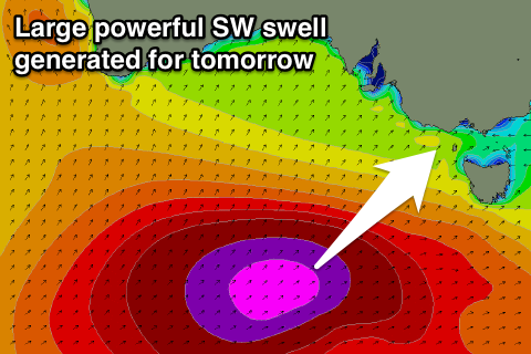
We've got some great satellite observations of the vigorous polar frontal system that's currently projecting up towards us, on top of an already active sea state.
50kt barbs have been observed, and the progression will continue generating severe-gale W/SW winds through our swell window today before moving across Tassie this afternoon and evening.
A large, powerful, long-period SW groundswell will result, peaking mid-morning tomorrow to a large 8ft across the Surf Coast reefs and swell magnets, with 10-12ft waves on the Mornington Peninsula.
 Winds aren't looking as favourable as they were on Wednesday but the Surf Coast reefs and other protected breaks will offer good challenging waves for experienced surfers.
W/SW breezes are due across most locations, with local W/NW offshores around Torquay all morning and possibly into the afternoon.
Sunday looks excellent for the Surf Coast with easing surf from the 4-5ft range with fresh NW tending W/NW winds. The Mornington Peninsula will likely continue to offer 6-8ft surf, easing during the day.
Our secondary S/SW groundswell for Monday is still on track, but with a slight downgrade. A broad but not overly strong polar front will develop south of WA this evening, projecting a fetch of strong to gale-force SW winds towards us.
A moderate sized swell should be generated for Monday, coming in around 4-5ft on the Surf Coast and 6-8ft on the Mornington Peninsula but with fresh SW winds. The Torquay region will likely see an early W/NW'ly
The swell will ease a touch into Tuesday, but weak trailing SW winds should keep 3-5ft waves hitting the Surf Coast with 6ft+ waves to the east as winds swing back to the W/NW.
Persistent polar fronts will continue to generate moderate amounts of swell for the rest of the week, but a SW change looks to move through Thursday. More on this Monday. Have a great weekend!
Comments
When you mention sea state. A quick read over the definition, suggests to me that the 'sea state' is all encompassing of a swell forecast i.e height and period. So that then leads me to believe that if there is a any given swell event, that if it occurs in a active 'sea state' that it will be a consistent swell event no matter how far it was generated from?
Ah not quite. Consistency is all relative to the distant from where the swell was generated to your coast. No matter how big the storm, if it's 1000's of km away, it will always be inconsistent. Hope that answers the question.
What you would get with a storm moving on top an active sea state is a mix of swells arriving at the same time, providing filler waves in between the larger sets. Hence it might feel a little more consistent.
Its answers my question, thankyou, but just leads to another haha. Is it possible to have consistent long period swells? The further the storm, the longer the period but in turn less consistent?
Yeah totally, this wil be one. Period is a function of wind strength and also longevity. So have a really strong storm like the current one, close to your coast and you'll get consistent long-period energy. There'll be lots of other lesser period swell trains in the mix as well though.
One day my questions will make sense and therefore hopefully easier to answer
It will be very consistent on the weekend
* Guaranteed !
*refund available
Haha
Let's keep an eye on this (Cape Sorell)..
Craig what rough rules do you apply to the Cape Sorrell data? i.e. does 6m significant height @ 14 seconds with a SW swell relate to 6ft surf at Bells?
Ha very vague ...
Is this the cape sorrel buoy craig?
Oh yeah, should have labelled.
There wasnt any options to which buoy that was !
Well there is one cdc ; http://www.bom.gov.au/products/IDS65030.shtml
Pt Nepean?
Crikey, this swell/period combo at Cape Sorell is very impressive - it has to be somewhere close to the top 10% for large swell events in this region, based on these figures.
There is some local windswell contamination in the mix (Cape Sorell AWS has been strong to gale-force onshore since Friday morning), but the current peak in size here is mainly groundswell as the wind trend has been slowly abating since Friday evening.
Only thing that can have a major regional effect on surf size here is direction. And this swell direction is fantastically SW.
And winds are light offshore on the Surf Coast.
Should be an incredible morning of large waves in Torquay.
Just to reference this swell against Hawaiian benchmarks (though, there's obviously a range of additional factors that influence surf size here compared to the Islands).
At 5:20am the Sorell buoy was recording Hsig of 7.3m and Tp of 17.5 seconds. So, that's 24ft at 17.5 seconds.
You're well above Eddie thresholds when those numbers are lighting up the 51101 buoy.
Thermalben thats very interesting thanks for the stats .
It would be somewhere in the top ten ive seen in the last 5 years of reading wa,sa & tas buoy data .
Xxl waves out there today !
Hope you get some! Winds look light over your way so should be great conditions. Would love to have the opportunity to scout the coast for new waves during this swell, but I'm just too busy unfortunately!
The Jan Juc reefs are just a pile of unorganized, lumpy 6 -8 (maybe the odd bigger one at B/W) foot poop. Save your petrol money kids........ya shoulda been here during the week.
WP is a mess too, very uninviting. Been much nicer swells this year
the swells not the prob, winds from the west - should swing NW for tomorrow
Much better this arvo in the bay!
You want a refund geek ?
Yes, yes I do
Gary gives credit where credit is due: it really was impressive to see that Sorrell boy shoot up yesterday and stay so erect for so long overnight.
Sunday was the pick - even better that half the reefs were deserted cause everyone was over at bells
Certainly looked much more user friendly to me Oiley; and was amazingly uncrowded. Tides weren't ideal but still so much fun.