Good fun waves for the Surf Coast

Victoria Forecast by Craig Brokensha (issued Monday 12th June)
Best Days: Surf Coast every day, east of Melbourne tomorrow afternoon, Thursday and Saturday morning
Recap
Excellent waves across the Surf Coast all weekend with easing 3-4ft waves Saturday, still in the 3ft range Sunday while the Mornington Peninsula was big on the beaches and better at Flinders and Western Port.
Today a renewal of swell energy has come in bigger than forecast with a bump back to 3-4ft on the Surf Coast with larger bumpier waves to the east.
This week (June 13 – 16)
Today's reinforcing groundswell will ease back into tomorrow but we'll see a mix of new long-range SW groundswell and building S/SW swell into the afternoon.
The long-range energy was generated in our far swell window and will be very very inconsistent, with today's swell likely providing the most size with infrequent 3ft sets at swell magnets on the Surf Coast and 4-5ft waves to the east.
A fun S/SW groundswell is due into the afternoon, generated by a strengthening polar front currently to our south-southwest. This should keep similar sized sets hitting both coasts before easing Wednesday from 2-3ft and 4ft respectively.
A light W/NW-NW offshore will create clean conditions on the Surf Coast tomorrow morning with variable breezes into the afternoon. This might open up some better options into the afternoon across the Mornington Peninsula.
 Wednesday will then see a moderate to fresh NW tending N/NW breeze, favouring the Surf Coast again.
Now, looking onwards to the strong but inconsistent W/SW groundswell due Thursday and there's been no real change to the expected size or timing of this swell.
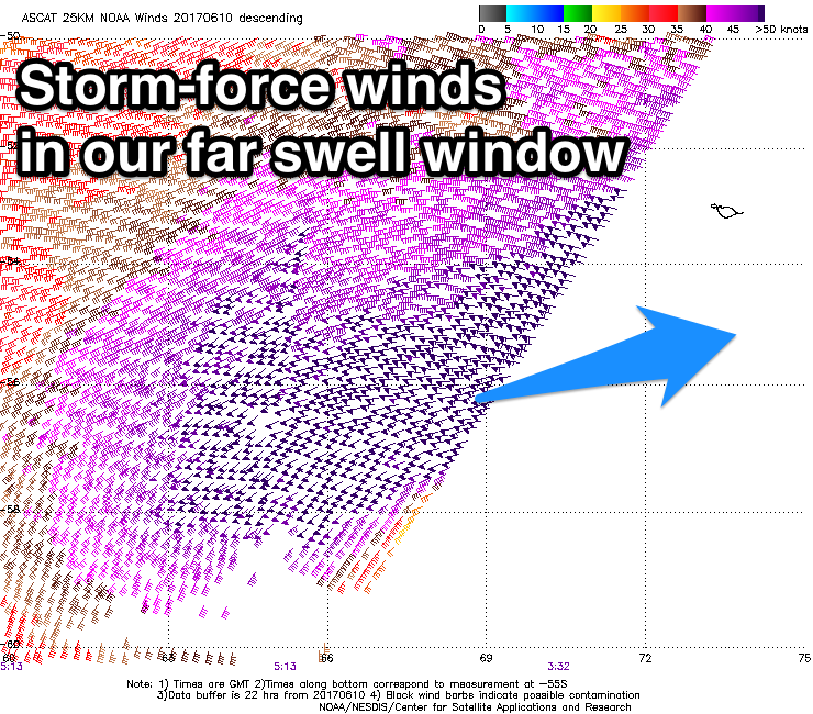
Over the weekend satellite observations confirmed a significant fetch of storm-force W/SW winds generated in our far swell window, and since we've seen a secondary front moving over the active sea state, closer towards WA and in our western swell window.
This front will then weaken and dip south-east under the Bight, but maintain a fetch of strong to gale-force W/SW winds in our swell window.
A fun sized W/SW groundswell should result with a mix of inconsistent long-range energy and more consistent mid-period swell, filling in Thursday and coming in at 3-4ft on the Surf Coast and 5-6ft+ on the Mornington Peninsula. There is likely to be the odd bigger bomb set at times, but these will be far and few between.
Conditions are looking excellent for the Surf Coast again with a NW offshore, persisting most of the day, similar Friday as the swell slowly eases.
Into the weekend we'll continue to see moderate amounts of W/SW swell energy from pre-frontal W/NW fetches moving in from the Indian Ocean and under the Bight.
The Surf Coast isn't expected to drop below 3ft, with 4-6ft waves on the Mornington Peninsula under N/NW winds Saturday, onshore Sunday with a strong SW change.
This change will be linked to a strong cold-outbreak, bringing with it a solid increase in stormy swell, but more on this Wednesday.