Lots of swell for Victoria, though quite west in direction

Victorian Surf Forecast by Ben Matson (issued Friday 2nd June)
Best Days: Plenty of fun waves most days in Torquay; biggest and best Mon/Tues/Wed (outside chance of funky winds late Mon, maybe also at some point Tues). East of Melbourne has potential Sun with light winds, then Thurs next week as winds and swells ease.
Recap: There's been no shortage of swell for the last few days though westerlies restricted the best conditions to Torquay on Thursday. Winds are now lighter across the coast though NW, best suited to the Surf Coast. Thursday managed 4ft sets west of Torquay and up to 6ft east of Melbourne, with a reinforcing swell maintaining 3ft and 4-5ft surf respectively today.
This weekend (Jun 3 - 4)
Surf conditions should remain favourable all weekend under a light NW breeze.
Today’s swell will ease slowly through Saturday, but a series of new long range W/SW swells will push through from Saturday evening into Sunday, slowly increasing size across the region.
Torquay should manage inconsistent 2ft+ sets early Saturday morning before surf size drops into the afternoon. East of Melbourne there won’t be enough size for protected spots, and there’s a risk that we’ll see average conditions at open beaches due to the extended spell of westerly winds this week. But size should be around the 4-5ft mark here early, smaller later.
On Sunday, for the most part a strong westerly component in the new, building swell direction will limit size and consistency in Torquay, but with clean conditions it’ll still probably be the pick of the coast, rebuilding to 2-3ft+ during the day (possibly a little undersized in the morning). Just remember that the sets will be very infrequent. I'll comment in the notes below over the weekend, as buoy data confirms the various phases of swell activity.
East of Melbourne will see considerably larger waves in excess of 6ft+ by Sunday afternoon, probably a little too small for Western Port but likely to be an ideal size range for the Flinders stretch.
Next week (Jun 5 onwards)
An excellent storm progression well SW of Western Australia this week has set up an XL swell event for the western coast of the country.
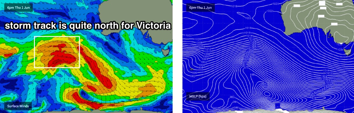
However, the significant travel distance onward to Victoria, combined with the northern latitude of the storm track (and thus strong W’ly component in the swell direction) means we’ll see surf size heavily diluted in Torquay.
A weak, unrelated front will also clip the state around Monday afternoon, swinging early offshore winds around to the SW. They shouldn’t be too strong and there is a chance that local topographical influences may keep the wind more west than anything else in Torquay, but it is certainly a risk. Winds should return to a light W/NW on Tuesday morning (perhaps a lingering SW east of Melbourne) and then more broadly light NW into Wednesday.
As for size, we’re looking at a large range in wave heights across the coast, anywhere from 3-4ft on the Surf Coast - and very inconsistent at times - but closer to 6-8ft at the East Coast’s open stretches. This swell will plateau from Monday afternoon through Tuesday before easing slowly from Wednesday onwards.
Beyond this, the broader patterns expected to remain vigorous across the Southern Indian Ocean, which suggests an extended period go moderate, long period groundswells for Victoria for next weekend and the following week. However with the storm track likely to remain primarily west of 130E, we probaly won't see any significant size on the Surf Coast.
More on this in Monday’s update.
Comments
it was a decent morning session on the SC - not overly large but great conditions on the reefs - looking forward to winter
Noice. Storm track looking very promising, just a shame it's so west.
never did the south arm notes and the automated forecast has been so off .. been a week ): when will craig be back ? any idea how long it takes for the models to recalibrate and have the correct input ?
Wave model should be back around now. So, moving forward it'll be fine from here on.
Sorry for the inconvenience, not much we could do.
Sorell picked up the new groundswell at 15 seconds last night, Pt Nepean actually picked up the leading edge at 16.7 seconds around 10pm. Should see a slow building trend during the day today.