Plenty of swell, cleanest Thursday

Victoria Forecast by Craig Brokensha (issued Monday 10th April)
Best Days: East of Melbourne Wednesday morning, Thursday, possibly Saturday morning Surf Coast, Sunday
Recap
Great waves across the Mornington Peninsula and Phillip Island Saturday with a moderate sized swell and fresh offshore wind, with smaller fun waves on the beaches across the Surf Coast.
Winds tended more NW Sunday with smaller surf west of Melbourne, while locations east of Melbourne saw a brief period of early N'ly winds.
A late change yesterday associated with a small intense low moving in from the west has brought with it an increase in windswell, along with a moderate sized SW groundswell, but conditions are poor with gusty onshore SW winds across the state.
This week (Apr 11 - 14)
Hi everyone, it's good to be back on board after a couple of weeks away overseas.
Coming in a little cold it looks like today's mix of groundswell and windswell from the low moving east across us will both ease tomorrow morning, but with poor conditions due to a moderate to fresh S/SW'ly. GFS is showing the slightest chance for an early W'ly around Torquay, but I don't like the chances of this at all.
With the low continuing east into Wednesday and Thursday winds will improve, swinging more variable from the east Wednesday morning, but more offshore locally across both coasts Thursday morning.
Two new SW groundswells are due through the coming days, the first tomorrow afternoon followed by a super long-period but inconsistent increase Wednesday.
The more consistent and better swell for tomorrow and Wednesday was produced by mid-range storm activity in our swell window and should come in at 3-4ft on the Surf Coast with sets in the 5-6ft range across the Mornington Peninsula both tomorrow afternoon and Wednesday.
As winds improve Thursday the swells should start to ease back from 3ft+ across the Surf Coast (3-4ft 13th Beach) and 4-5ft+ along the Mornington Peninsula.
 Later in the day Thursday an onshore change is expected as a front associated with some new W/SW swell clips the state. This front will leave onshore S/SW winds into Friday, spoiling the new building W/SW swell energy.
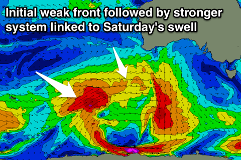
Two W/SW swells are due, the first and smallest for the morning produced by a pre-frontal fetch of W/NW gales south-west of WA, while a better trailing fetch of broader W/SW winds will be linked to a bigger afternoon increase.
Exposed breaks should reach 3ft on the Surf Coast into Friday afternoon, with 4-6ft sets on the Mornington Peninsula.
This weekend onwards (Apr 15 onwards)
On the backside on the frontal system responsible for Friday afternoon's W/SW swell, we'll see a good and strong polar front project a fetch of W/SW gales nicely over an active sea state and through our western swell window.
We'll see a moderate sized W/SW groundswell for Saturday, coming in at 3-5ft across magnets on the Surf Coast and 6ft+ on the Mornington Peninsula. Conditions are looking a bit better than Friday but still possibly dicey with lingering onshore SW winds (possibly W/NW around Torquay through the morning).
A temporary drop in swell is expected Sunday morning ahead of a good long-period SW groundswell building through the day.
We can expect a little less consistency from this swell as it will be generated by a vigorous polar low south-west of WA, weakening as it moves closer into our swell window.
A good kick back to 3ft to occasionally 4ft is expected on the Surf Coast into the afternoon, 5-6ft on the Mornington Peninsula under offshore N'ly winds, favouring the beaches across both coasts.
Longer term we've got a dynamic and tricky setup with a strong and broad cut-off low due to develop south of the country. This looks to bring swell but also wind, so check back Wednesday for another look at this.