Strong swells over the coming period

Victoria Forecast by Craig Brokensha (issued Wednesday 15th February)
Best Days: Both coasts tomorrow morning, Surf Coast Friday, Surf Coast Saturday morning, Torquay early Sunday, east of Melbourne Tuesday morning
Recap
Not the best conditions early on the Surf Coast yesterday but winds tended light onshore creating fun surf through the day with easing waves from the 4ft range. The Mornington Peninsula was bigger but bumpier.
Today conditions were much better across all locations with a light morning offshore and good easing sets from 3ft on the Surf Coast and 3-5ft on the Mornington Peninsula.
This week and weekend (Feb 16 - 19)
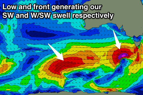
Early tomorrow morning will be a low point in swell activity but from mid-late morning a strong and powerful new SW groundswell is due to fill in, peaking through the late afternoon/evening.
The frontal system generating this swell is currently strengthening south of the Bight with forecasts indicating a fetch of severe-gale to possibly storm-force W/SW winds being generated through our immediate south-western swell window.
The swell should build rapidly, reaching 4-5ft on the Surf Coast and 6-8ft on the Mornington Peninsula, easing back from the 4ft range and 6ft+ range respectively Friday morning.
 Conditions tomorrow morning will be OK but not perfect with a light variable wind ahead of SE sea breezes, while Friday looks great on the Surf Coast with a morning NW offshore, tending lighter W/NW ahead of a late change (possibly on dark).
This offshore wind will be linked to a strong and slow moving secondary polar frontal progression moving up from the Southern Ocean towards us.
The front is already generating a fetch of severe-gale W/SW winds through our south-western swell window, but will project towards the Bight while weakening slightly and moving more through our western swell window. The front will then continue moving closer to us while slowly weakening Friday and Saturday.
A large W/SW groundswell should be generated, building through Saturday, peaking overnight and easing Sunday.
Exposed breaks on the Surf Coast should see 6ft sets into Saturday afternoon with 8-10ft waves on the Mornington Peninsula, easing back from 4-6ft and 8ft+ respectively Sunday morning.
Winds on Saturday morning as the swell builds will be OK in protected spots on the Surf Coast and from the W/NW, tending W/SW late morning, while Sunday is likely to see SW breezes (early from the W around Torquay).
Into early next week the swell is expected to continue easing with lingering onshore winds across both coasts, while the Mornington Peninsula should see better conditions on Tuesday with a morning NE'ly.
Longer term some new W/SW swell energy is due later next week, but more on this Friday.
Comments
Yeww!
Looking so good I'm considering driving from Melbourne out to Echuca just so I can drive all the way from Echuca to Winki for a surf.
Driving from Echuca to Winki for a surf! That's a pretty hard core drive but by the looks of that graph that Craig posted below it could be worth it. A mate of mine is driving down from Canberra tomorrow morning. You should get in contact with him. He could pick you up and you could share the petrol costs.
Me again Surfer99. I just realised the problem with this plan is that if my mate picks you up your car would be in Echuca. You would have to get a lift back with him on Sunday arvo. Then it would be a be a big drive back to Melbourne on Sunday night, presuming you have a job that you have to go to on Monday morning. It's a logistical nightmare, but it'll be an epic mission if you can pull it off!
Swell is kicking at Cape Sorell, keep an eye out late morning for some size.
Really started kicking from 11am onwards down around Cape Otway. Unfortunately the wind came up sooner than expected but it wasn't too strong
Nice, yeah the buoy readings are really strong. Tomorrow will be really good!
Looks really good today! Just a bit jealous. The weekend outlook has improved re winds as well!