Easing surf, cleanest east of Melbourne

Victoria Forecast by Craig Brokensha (issued Wednesday 21st December)
Sign up to Swellnet’s newsletter and receive the Victorian Forecaster Notes and latest news sent directly to your inbox. Upon signup you'll also enter the draw to win a surf trip to P-Pass for you and a mate. It doesn’t get much easier so click HERE to sign up now.
Best Days: Both coasts Sunday and Monday mornings, Tuesday morning Surf Coast, Wednesday morning Surf Coast, Thursday both coasts
Recap
Really poor conditions yesterday with tiny amounts of swell and a fresh onshore wind, while today some new W/SW swell is building with the strongest surf due this afternoon.
Torquay was clean with a morning offshore and 3ft sets, but the early high tide created a few issues. Bigger bumpier waves were seen to the east. An onshore change is due late morning and we should see the surf reaching 3-4ft on the Surf Coast this afternoon with 6ft+ waves on the Mornington Peninsula.
This week and weekend (Dec 22 - 25)
This afternoon's peak in W/SW groundswell will be followed by a gradual easing trend through tomorrow, further Friday and smaller again into Saturday.
Conditions are a little tricky tomorrow, with the American GFS model going for an early variable breeze. The higher resolution BOM 3 day model has a light to moderate S/SE'ly though, so one eye on the local observations and other on the surfcams for a dawny would be best. If the wind is only light onshore, the Surf Coast beaches should still be OK.
The Surf Coast should still have 3ft+ sets at magnets through the morning, with easing 4-6ft waves on the Mornington Peninsula.
The beaches east of Melbourne are still looking fun Friday with an E/NE to NE breeze due to develop along with fun easing 3-4ft sets, while the Surf Coast will be small and easing from 2ft.
The weekend is looking very slow swell wise, with inconsistent background W/SW energy from the southern Indian Ocean expected to keep the Mornington Peninsula beaches active.
The Surf Coast is due to be tiny and around 1ft, but infrequent 2-3ft sets should continue east of Melbourne Saturday and Sunday.
Winds are looking decent for these locations with E/NE-NE offshores ahead of sea breeze, but we'll have to review this Friday as the European model has a slightly less favourable forecast.
 Next week onwards (Dec 26 onwards)
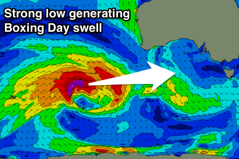
Into Boxing day a new long-range but strong long-period W/SW groundswell is due to fill in.
This is being generated by a very strong low firing up in the southern Indian Ocean this afternoon, producing a fetch of severe-gale to storm-force W/SW winds through our western swell window.
The low will weaken south-west of WA resulting in a fair bit of loss in size and consistency.
In saying this we should see the Surf Coast building to an inconsistent 3ft through the mid-late afternoon with 6ft sets on the Mornington Peninsula, but an early N'ly breeze is due to give into a S'ly change.
The swell is expected to ease Tuesday under strong E/SE winds kicking up a low quality windswell. More on this Friday.
Comments
The WAMS look pretty good windwise for tues/wed/thurs next week?