Not the best weekend, fun Monday

Victoria Forecast by Craig Brokensha (issued Friday 16th December)
Sign up to Swellnet’s newsletter and receive the Victorian Forecaster Notes and latest news sent directly to your inbox. Upon signup you'll also enter the draw to win a surf trip to P-Pass for you and a mate. It doesn’t get much easier so click HERE to sign up now.
Best Days: Keen surfers Surf Coast tomorrow morning, beaches Monday morning, Surf Coast Wednesday morning
Recap
A strong SW groundswell across the coast yesterday, peaking into the afternoon but with average S/SE winds, limiting clean conditions to a few selected spots.
This morning the swell was still up around 3ft with 4ft sets at 13th Beach on the Mornington Peninsula and 4-5ft on the Mornington Peninsula but with average conditions at dawn.
The surf has since started to improve as expected with offshores developing on the Mornington Peninsula, and lighter variable winds on the Surf Coast.
This weekend (Dec 17 - 18)
We should see the surf continuing to ease off this afternoon, further into tomorrow with 2ft to possibly 3ft sets across swell magnets on the Surf Coast and waves in the 4ft range on the Mornington Peninsula.
A morning W'ly wind will favour protected breaks on the Surf Coast ahead of a strong SW change late-morning and building windswell.
This change has been strengthened since Wednesday and the windswell from the W/SW is looking bigger into Sunday.
This will be mixed in with an inconsistent SW groundswell from a polar low the last few days, with 2-3ft waves due on the Surf Coast and 4-5ft sets on the Mornington Peninsula.
Conditions are due to be average though with a SW tending S/SE breeze, although Torquay is likely to see an early W'ly for keen surfers.
Next week onwards (Dec 19 onwards)
 Monday is still looking the best day to hit the beaches east of Melbourne with an offshore N/NE wind and easing 3-4ft sets, with the Surf Coast backing off from 2ft with N/NE tending N/NW winds likely ahead of sea breezes.
Come Tuesday a W'ly change and tiny swell on the Surf Coast will leave no quality options for a wave.
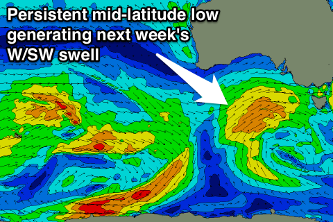
A good new W/SW groundswell is on the cards for Wednesday though, generated by a strong but weakening mid-latitude low pushing in from South West of WA, aiming a broad and persistent fetch of strong W/SW winds under the country Sunday through Tuesday.
The low is actually expected to restrengthen while approaching us Tuesday afternoon and evening, producing a moderate to large sized W/SW swell event for Wednesday, tending SW and easing Thursday.
The Surf Coast should build to 3-4ft+ through the day Wednesday, with 6-8ft sets on the Mornington Peninsula, easing Thursday.
A morning W/NW breeze is due Wednesday, ahead of a W/SW change and then S/SW winds Thursday. More on this in the next update. Have a great weekend!
Comments
Good to see the Surf Coast clean right up as expected.
Ok. Im working 200meters from sorra back and the wind is blowing up the street implying the wind is coming from the north and the flag in main street comfirms that. Yet its SE on the on the ocean. how how HOW!?
I was thinking it's maybe because one of the wind directions hasn't overpowered the other one yet? If that's even possible?
called a seabreeze
and what happens 100m inland?
Hey Craig,
Are you still expecting the wind to swing N/NW on the surf coast during the morning tomorrow, and maybe a tough a more size becuase it was 3-4ft this morning?
Cheers love your work
VS, yeah it's a very good chance mid-late morning.
Sorry to go all science 1.01 on ya...but it's cos of Convection... (stored energy transfer)https://en.wikipedia.org/wiki/Convection
The wind on the (usually hotter land) blows toward the cooler ocean..and the two meet, creating variable winds if both are similar temps...but stronger prevailing winds can also affect it all at different levels (lower and upper atmosphere)...usually the temps gotta get well above 25deg for the North's to truly kick in..but the affects on inland heat will also create the prevailing winds too...so in effect, the affect can be different depending on where you stand ay??
Either way...if you got time to be on the beach, if the weather ain't squalling or knocking off ya feet..any wave (wind affect or what) is better than no waves at all.
;-) Timm.
How does that work at Sorrento where a thin strip of land is surrounded by two large bodies of water?
Ive always wondered if port phillip bay works like a mini lake Nicaragua assisting in offshore flows. Not that we get offshores all that much (although willyweather wind vein records northlies as the most persistent over 5 years at 15.22%?) But as you said about a thin stretch in between two bodies of water maybe something unique can tale place?
Is there a wave buoy for Bass Strait available now Port of Melbourne no longer do it and the new owners don't seem to be bothered. The lack of real time wave information is really doing my head in
Here it is: http://portofmelbourne.com/waves-wind-and-weather
Bloody legend thanks mate!
Hey Craig my balls are a bit itchy, I'm feel'in abit lazy couldn't give'm a bit scratch for me mate. Thanks in advance, your as they say, a Lege. :-))
Love you too Shaun!
Hey Wharfjunkie, based on some comments above it seems to Gary that you're doing it all wrong using your 'eyes , experience and observations' as a source of real time information.
Maybe it's time to invest in a VR headset with the Nepean wave buoy broadcasting full time. Gary picked up a VR headset recently with his entry ticket to Sexpo and you're welcome to have a loan, it's still in pretty good condition despite copping a fair bit of use recently.