Large clean swell for the Surf Coast Wednesday

Victoria Forecast by Craig Brokensha (issued Monday 17th October)
Best Days: Protected spots Surf Coast tomorrow afternoon, Surf Coast Wednesday, Thursday, Friday morning Surf Coast
Recap
Small inconsistent background groundswell energy over the weekend with favourable winds for swell magnets up until midday yesterday.
Today the surf has remained small with a W/SW swell and offshore winds for the Surf Coast, bumpy to the east.
This week (Oct 18 - 21)
As has been discussed since Monday last week, we're set to see a strong and powerful W/SW groundswell mid-week, generated by a storm that developed in the southern Indian Ocean late last week.
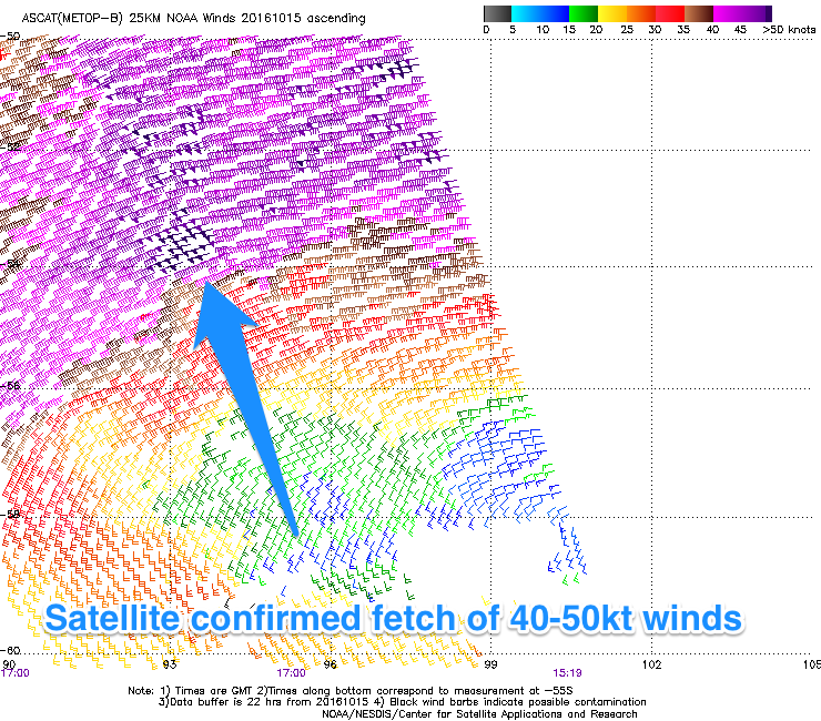 This storm has been generating a fetch of severe-gale to storm-force W/SW winds, confirmed by satellite observations, and is now weakening but broadening while projecting nicely towards the south-east of the country.
What we'll see through tomorrow is mid-period W/SW swell energy building and growing in strength, generated by the weakening storm tracking towards and then into us.
The Surf Coast is only expected to be small and weak around 2ft through the morning, building gradually through the day and reaching 3-4ft by dark, while the Mornington Peninsula will be larger but average with a fresh W/NW tending W'ly breeze.
With this W'ly breeze, protected spots on the Surf Coast are worth a look later in the day.
The groundswell proper is due to peak Wednesday to 5-6ft on the Surf Coast and 8ft+ on the sets across the Mornington Peninsula. Swell magnets on the Surf Coast are likely to see larger bombs to 8ft at the peak of the swell, and winds will favour the reefs with a moderate but easing W/NW wind (variable into the afternoon). If it does tend onshore it will only be light from the W/SW or so.
It's also worth noting, with the strongest winds being in our far swell window, these larger bombs sets will be the least consistent of the bunch.
The swell should ease from Wednesday afternoon, dropping back from around 4ft on the Surf Coast Thursday morning and 6ft+ on the Mornington Peninsula. A front approaching from the west will steer winds more N'ly across the coast, favouring the beaches and selected spots handling the swell to the east.
This front will also produce a small reinforcing W/SW groundswell for Friday, slowing the easing trend across the state. No major size is due though with 2-3ft sets at swell magnets on the Surf Coast and 4-5ft+ waves on the Mornington Peninsula with funky winds. A fresh to strong N'ly at dawn is likely to give into a W'ly change, leaving protected spots on the Surf Coast with small clean waves.
This weekend onwards (Oct 22 onwards)
The initial W'ly change on Friday will give into a S/SW change on Saturday leaving no decent surfing options with small to moderate levels of W/SW and SW swell.
Saturday afternoon a distant SW groundswell is due to arrive, generated by a fetch of distant strong to gale-force W/SW winds at the base of the front moving through at the end of the week.
2-3ft surf is expected west of Melbourne later Saturday and early Sunday with inconsistent 4-5ft sets on the Mornington Peninsula. S/SW winds will continue to create average conditions on Sunday though.
Longer term a couple of moderate sized pulses of SW groundswell are due into next week from strong polar storms, but more on this Wednesday.
Also; have you ever wanted to own a pristine beachfront development site for sale in North Sumatra. Suitable for boutique project of 5 bungalows and restaurant. Visit here for details.