Easing swell with a weak onshore tomorrow, cleaner on the beaches Friday

Victoria Forecast by Craig Brokensha (issued Wednesday 12th October)
Best Days: Keen surfers Surf Coast tomorrow, east of Melbourne Friday and Saturday
Recap
Conditions were a bit better than expected yesterday morning on the Surf Coast with a W/NW breeze and mix of W/SW and building SW swell. Sets were around 3-5ft before kicking to a stronger 6ft into the afternoon as winds swung W/SW. This continued to create workable conditions on the reefs for keen, experienced surfers.
Today the SW swell was on the ease with good offshores across the Surf Coast again, dropping from 3-5ft. To the east, Western Port was the only real option.
This week and weekend (Oct 13 - 16)
Yesterday's large SW groundswell will continue to ease off over the coming days, slowed only slightly by a weak front currently south-west of us.
The Surf Coast is expected to drop from 3ft tomorrow, back from a smaller 2ft Friday. The Mornington Peninsula is likely to still be solid and around 5ft+ tomorrow morning, smaller and 3ft+ Friday morning.
Conditions won't be perfect but workable tomorrow, with an onshore change this afternoon due to leave a much weaker and weakening S/SE breeze across all coasts tomorrow.
Friday will then be great on the beaches with a N/NE offshore, tending variable ahead of possible mid-late afternoon sea breezes.
Into Saturday the surf will be very small and inconsistent, with us relying on a distant SW groundswell from the Indian Ocean. Swell magnets should see 1-2ft sets on the Surf Coast, with 3ft+ sets on the Mornington Peninsula.
A gusty N'ly breeze will be workable across select beaches east of Melbourne, more N/NW on the Surf Coast.
A weakening westerly change due through Sunday looks to be delayed and with this early N/NW winds and no decent swell won't provide any decent surfing options across the state. We'll have a review on the timing of this front Friday though.
 Next week onwards (Oct 17 onwards)
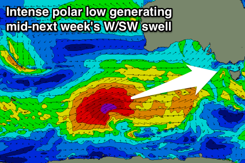
As touched on last update, a strong pulse of W/SW groundswell is due mid-next week from a vigorous polar low forming east of Heard Island, projecting slowly towards the Bight while slowly weakening but expanding in size.
Ahead of the large swell due from this front, some smaller W/SW swell is due from weaker pre-frontal winds, but more on all of this Friday.