Surf Coast good fun all week

Victoria Forecast by Craig Brokensha (issued Monday 3rd October)
Best Days: Surf Coast all week, selected locations east of Melbourne Thursday, early Saturday Torquay, both coasts Sunday
Recap
Fun clean 2-3ft waves on the Surf Coast Saturday with the best conditions around Torquay under W/NW breezes. The Mornington Peninsula was average and bumpy.
Sunday was small to tiny, weak and fading on the Surf Coast to 1ft to occasionally 2ft with better 3ft waves on the Mornington Peninsula under N'ly winds.
Today a very inconsistent new W/SW groundswell due across the coast hadn't hit the Cape Sorell buoy with any real vigour or impacted the Victorian coast. This has resulted in tiny bumpy waves across most locations besides Torquay which was clean.
We should see some better sets develop during the day on the Surf Coast, but probably only to 2ft or so under gusty W/NW-NW winds.
This week (Oct 4 - 7)
The Surf Coast will be the pick this week with moderate amounts of W/SW groundswell due, but the size has been downgraded a touch since last week due to the frontal systems moving through our swell window being a touch weaker.
Currently a vigorous front is just to our west-southwest, with it pushing through the Bight yesterday and early this morning while generating a fetch of W/SW gales.
A new W/SW groundswell is due off this system, filling in tomorrow morning, but the front proper will move through later this afternoon and evening, adding some additional short-range W/SW to the mix.
This will then be followed by a weaker fetch of strong W/SW winds moving through the day tomorrow.
 What we can expect is a consistent mix of long-period and mid-period energy causing some weird double ups, but the Surf Coast should build from the 3ft+ range, more towards 4ft into the afternoon, with the Mornington Peninsula kicking to 6ft to occasionally 8ft.
Conditions will be best around Torquay with a fresh and gusty W/NW breeze.
A drop in size is due Wednesday morning from 3-4ft and 6ft+ respectively. The Surf Coast will be the pick again with a strengthening NW tending W/NW breeze.
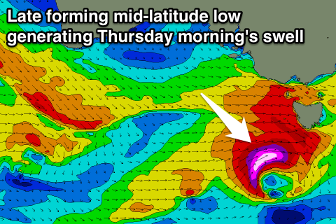
One final pulse of moderate sized W/SW groundswell is due Thursday morning from a late forming mid-latitude low just south-west of us on Wednesday. A fetch of pre-frontal W/NW gales will be followed by severe-gale W/SW winds (possibly storm-force), just in our swell window before moving across Tassie.
This should keep 3-4ft sets hitting the Surf Coast Thursday morning and 6ft+ waves on the Mornington Peninsula (possibly bigger if the low intensifies earlier), easing back into the afternoon further Friday. NW winds will open more options Thursday with NW breezes ahead of a SW change Friday.
This weekend onwards (Oct 8 onwards)
A weak surface trough is due to move through Saturday bringing S/SW winds, but Torquay may see an early W/NW breeze. A new pulse of W/SW groundswell is due, generated by a very tight but intense mid-latitude low tracking east-southeast through our swell window. Due to this, the Surf Coast is likely to only see 3ft sets.
Longer term we're likely to see a much more significant low forming right to our south-west later next weekend/early the following week, but more on this Wednesday.
Comments
The new swell has finally hit Cape Sorell with some size, and Pt Nepean is also on the way up.
A great example of what I was talking about in the notes above, see the close spaced waves ahead of the larger set behind it.
"What we can expect is a consistent mix of long-period and mid-period energy causing some weird double ups"
nice craig
Good to see the swell kicking late yesterday.