Fun waves tomorrow, dicey Wednesday then average for the rest of the week

Victoria Forecast by Craig Brokensha (issued Monday 19th September)
Best Days: Both coasts tomorrow, east of Melbourne Wednesday morning, possibly to the west through the day, east of Melbourne Saturday
Recap
Fun waves all weekend on the Surf Coast, most consistent Saturday with Sunday's swell being more long-range energy. The Mornington Peninsula was good and clean Saturday, while Sunday saw less favourable winds from the west, creating bumpy conditions.
Today we're expecting a mix of swells to fill in, biggest into the afternoon to 3-4ft on the Surf Coast and 5-6ft+ on the Mornington Peninsula, and this morning the size was tracking nicely, with the Surf Coast offering the cleanest conditions under W/NW winds. Winds should tend more variable into the afternoon, seeing improving conditions to the east.
This week (Sep 20 - 23)
This afternoon's strongest pulse of SW groundswell, generated by post-frontal W/SW gales along the polar shelf late last week, should ease back into tomorrow morning.
The Surf Coast should see 3ft sets through the morning, with 4-5ft+ waves on the Mornington Peninsula under N'ly winds, tending N/NE into the late afternoon.
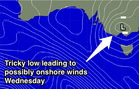 Our new pulse of W/SW groundswell for Wednesday is still on track, generated by a vigorous front piggy-backing over the top of the low generating today's swell, pushing towards WA and then through the Bight while weakening today.
This swell is expected to fill in through the early morning and peak through the day to 3ft+ at exposed spots to the west swell on the Surf Coast and 5-6ft on the Mornington Peninsula.
Winds are tricky and still a little in the air, as the models diverge on a low drifting in from the west. The BOM 3 day high resolution model as E/NE tending N/NW winds which would favour both coasts through the day, but GFS has E/NE tending variable SE winds.
Therefore the best is to keep an eye on the BOM regional forecasts and the comments below for an update tomorrow.
Into Thursday the low is expected to be positioned to our east and with this we'll see poor S'ly winds with easing levels of W/SW swell.
Friday should steady in size, as a small reinforcing W/SW groundswell fills in but winds might still be lingering from the S'th, more on this Wednesday.
This weekend onwards (Sep 24 onwards)
Saturday will be small and best east of Melbourne with N/NE winds. The beaches should offer 3-4ft sets early, with fading 2ft sets on the Surf Coast.
The next increase in significant swell is hard to pin down. We may see some weak W/SW windswell for Sunday as a front pushes through, but the models diverge on this. Beyond this, there's nothing too significant but more on this Wednesday.
Comments
Looks like the winds won't be too favourable for the Surf Coast tomorrow. Variable at best early and then increasing from the S/SE during the day.