Smaller surf with light winds over the weekend, E'ly swell possible early next week

Victoria Forecast by Craig Brokensha (issued Friday 3rd June)
Best Days: Both coasts Saturday morning, east of Melbourne Sunday morning, Surf Coast Monday afternoon, Tuesday and then both coasts Wednesday
Recap
A good but inconsistent new W/SW groundswell across the state yesterday to 3ft to occasionally 4ft on the Surf Coast and 6ft on the Mornington Peninsula. Conditions were great all day east of Melbourne, while Torquay started a little average and bumpy but improved as winds remained variable into the afternoon.
This morning however conditions were poor around Torquay with a moderate easterly wind and easing swell from 2-3ft, better and more workable at 13th Beach and best to the east of Melbourne again.
This weekend and next week (Jun 4 - 10)
Conditions tomorrow morning are now looking a little better across the Surf Coast with a more variable breeze likely through the morning and leftover 2ft+ sets. The Mornington Peninsula will be clean as well with the variable breeze (tending NE) and 3-4ft+ sets. With the troughy weather winds are likely to remain light most of the day before tending S/SE at some stage through the afternoon.
Into Sunday our new inconsistent long-range W/SW groundswell is still due, building through the day and coming in at an inconsistent 2ft across exposed on the Surf Coast and 3ft to occasionally 5ft on the Mornington Peninsula.
Variable winds are likely to favour both coasts through the morning again, increasing from the W through the afternoon.
Into Monday morning there'll be no real decent W/SW swell left and we may actually see some E/SE groundswell developing on the southern ends of the Surf Coast from a large groundswell impacting the East Coast.
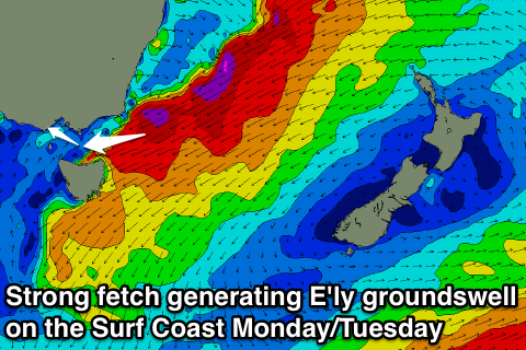 A fetch of severe-gale to storm-force E/NE winds will be aimed towards Eastern Bass Strait and we should see small lines of E/SE groundswell spreading into the Surf Coast through Monday building into the afternoon.
3ft sets aren't out of the question into the afternoon, easing back from the 2-3ft range Tuesday morning. This swell won't impact the Mornington Peninsula.
At the same time Monday afternoon a small W/SW swell should be seen across the Mornington Peninsula, generated by a small and intense but unfavourably aligned mid-latitude low pushing up and into Adelaide.
A slight increase in size to 3-4ft is due, and only 1-2ft on the Surf Coast. Moderate to fresh W/NW tending winds will favour the Surf Coast over the Mornington Peninsula though, persisting from the NW to W/NW Tuesday.
Into Wednesday our strong long-period and inconsistent W/SW groundswell is still on the cards, with a vigorous polar low due to form in the Heard Island region through this afternoon, projecting a broad and prolonged fetch of severe-gale to storm-force SW winds towards Western Australia.
A large long-period W/SW groundswell will be generated with the fore-runners due to arrive later Tuesday with the swell peaking Wednesday to an inconsistent 3-5ft on the Surf Coast and 6ft to possibly 8ft on the Mornington Peninsula. Winds are looking favourable and offshore from the N'th at this stage but we'll review this Monday. Have a great weekend!
Comments
So monday if theres a possibilty of a East swell for surf coast and WSW for us. Wouldnt they have to collide at some point making peaky swell? Wishful thinking
An easterly groundswell forecast for the surf coast! First for everything!!
Hey Craig,
I made a forum but just in case no one responds would you be able to explain in detail what happenes to reef breaks and beachbreaks when there's a east swell direction particularly in this instance the surf coast?
Yeah it's a funky one.
Here's my reply..
"It's quite rare and could possibly be blocked by the islands at the entrance to Bass Strait but I think there is enough size to overcome this.
Will be interesting to keep an eye on the Lorne Surfcam.
But really it won't be too dissimilar to a stronger period south-east windswell."
So it doesn't really change the way the waves break on reefs or beachbreak like I thought I read somewhere it makes the waves peakier but I might of miss read it
Cheers for the reply
Not really, when combinging with a SW swell it may create some decent peaks, but that's just luck.